Massive, shallow and deadly earthquake M 8.2 struck Chile
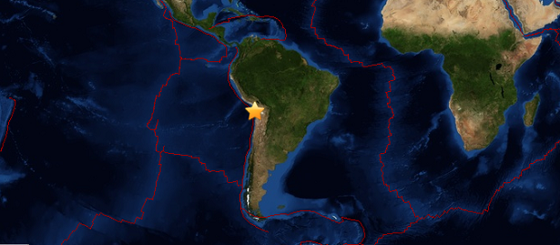
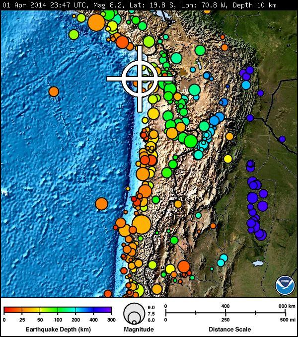
Powerful, shallow and deadly earthquake M 8.2 struck NW of Iquique, Chile on April 01, 2014 at 23:46 UTC. USGS repored depth of 20 km (12.5 miles). EMSC is also reporting M 8.2 at depth of 20 km.
The epicenter was located at coordinates 19.642°S 70.817°W – 95 km (59 miles) NW of Iquique, Chile, 139 km (86 miles) SSW of Arica, Chile, 190 km (118 miles) SSW of Tacna, Peru, 228 km (142 miles) SSE of Ilo, Peru and 447 km (278 miles) SW of La Paz, Bolivia. The epicenter was at depth of 20 km (12.5 miles).
.jpg)
This earthquake was followed by series of strong aftershocks with strongest recorded as M 6.2 with epicenter 88 km N of Iquique, Chile.
USGS issued Yellow PAGER alert notice for shaking-related fatalities and economic losses. Past yellow alerts have required a local or regional level response.
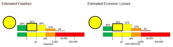
Orange alert level was issued for economic losses. Significant damage is likely and the disaster is potentially widespread. Estimated economic losses are less than 1% of GDP of Chile. Past events with this alert level have required a regional or national level response.
A tsunami warning and watch are in effect for Chile and Peru.
TSUNAMI BULLETIN NUMBER 005
PACIFIC TSUNAMI WARNING CENTER/NOAA/NWS
ISSUED AT 0235Z 02 APR 2014
... A TSUNAMI WARNING AND WATCH ARE IN EFFECT ...

A TSUNAMI WARNING IS IN EFFECT FOR

 CHILE / PERU
SEA LEVEL READINGS INDICATE A TSUNAMI WAS GENERATED. IT MAY HAVE BEEN DESTRUCTIVE ALONG COASTS NEAR THE EARTHQUAKE EPICENTER AND COULD ALSO BE A THREAT TO MORE DISTANT COASTS. AUTHORITIES SHOULD TAKE APPROPRIATE ACTION IN RESPONSE TO THIS POSSIBILITY. THIS CENTER WILL CONTINUE TO MONITOR SEA LEVEL DATA TO DETERMINE THE EXTENT AND SEVERITY OF THE THREAT. FOR ALL AREAS - WHEN NO MAJOR WAVES ARE OBSERVED FOR TWO HOURS AFTER THE ESTIMATED TIME OF ARRIVAL OR DAMAGING WAVES HAVE NOT OCCURRED FOR AT LEAST TWO HOURS THEN LOCAL AUTHORITIES CAN ASSUME THE THREAT IS PASSED. DANGER TO BOATS AND COASTAL STRUCTURES CAN CONTINUE FOR SEVERAL HOURS DUE TO RAPID CURRENTS. AS LOCAL CONDITIONS CAN CAUSE A WIDE VARIATION IN TSUNAMI WAVE ACTION THE ALL CLEAR DETERMINATION MUST BE MADE BY LOCAL AUTHORITIES.
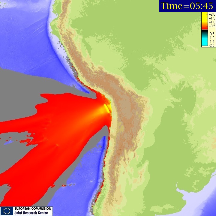
Tsunami maximum wave height (Source: JRC) See animation
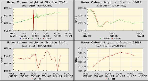
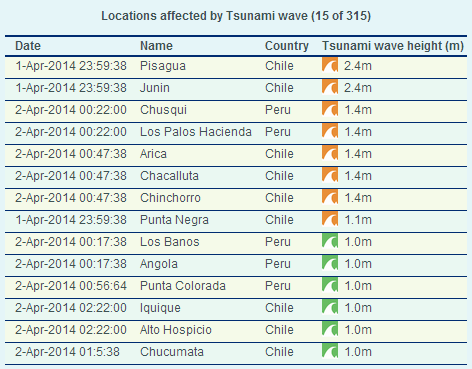
Buoy readings – Station 32401 – 260 NM West-Southwest of Arica Chile and Station 32412 – SOUTHWEST LIMA – 645 NM SW of Lima, Peru (Credit: National Data Buoy Center)
(Source: GDACS)
Updates
The tsunami warning has officially been canceled. Many of those evacuated due to the tsunami have returned home.. There are many reports of infrastructural damage in Chile and Peru. This massive earthquake occurred after numerous very strong earthquakes during the last couple of weeks.
A couple of buildings have been flooded because of the tsunami in Iquique. The mayor of Iquique said the water entered 3 blocks inland or at least 100 meter.
80% of the fishing fleet in La Caleta is damaged!
Landslides have killed another 3 people (1 woman and 2 men).
Shortly after the earthquake looting started in a few cities. More police and special forces are on their way by plane to the northern Chile to assist the local police in preventing further looting.
The death toll from this earthquake still remains at 5 – with them all being indirect. (07:00 UTC)
There has been slight damage to buildings, and the power network along the coast. Checks are being done as to the structural safety of these buildings before people go back in.
A number of people have been injured (at least 13 across the region).
The chaos, and a collapsed wall, allowed some 300 inmates to escape a women's prison in Iquique, the city closest to the huge quake's epicenter. Authorities said 110 of them had been recaptured.
The sea rushed 200 meters inland, flooding some streets, authorities said. Fishermen reported that 80 boats had been destroyed, sunk or floated out to sea.
#CHILE: Fishermen try to salvage their boats in aftermath of earthquake & tsunami http://t.co/rF6wNaMDgY pic.twitter.com/Q2v7CNfpjg
— RT (@RT_com) April 3, 2014
The following videos were recorded on April 1, 2014:


Update 10:39 UTC, April 2: A 6th person has been killed by the earthquake, Minister of the Interior Rodrigo Peñalillo said to the press a shortwhile ago. (ER)
Tectonic summary
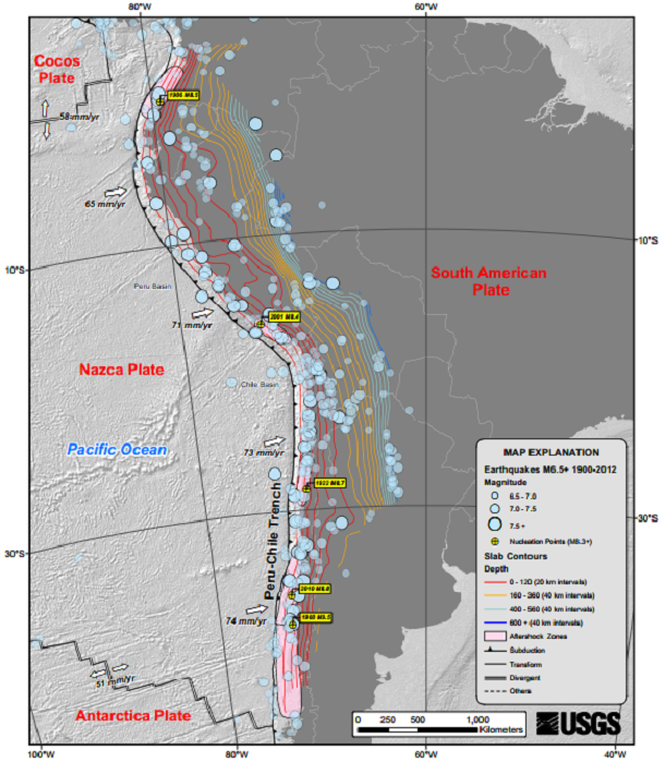
The April 1, 2014 M8.2 earthquake in northern Chile occurred as the result of thrust faulting at shallow depths near the Chilean coast. The location and mechanism of the earthquake are consistent with slip on the primary plate boundary interface, or megathrust, between the Nazca and South America plates. At the latitude of the earthquake, the Nazca plate subducts eastward beneath the South America plate at a rate of 65 mm/yr. Subduction along the Peru-Chile Trench to the west of Chile has led to uplift of the Andes mountain range and has produced some of the largest earthquakes in the world, including the 2010 M 8.8 Maule earthquake in central Chile, and the largest earthquake on record, the 1960 M 9.5 earthquake in southern Chile.
The April 1 earthquake occurred in a region of historic seismic quiescence – termed the northern Chile or Iquique seismic gap. Geodetic modeling indicates that the subducting and overriding plates are partially to fully-locked, implying that large earthquake are possible along the plate boundary megathrust. Historical records indicate a M 8.8 earthquake occurred within the Iquique gap in 1877, which was preceded immediately to the north by an M 8.8 earthquake in 1868.
A recent increase in seismicity rates has occurred in the vicinity of the April 1 earthquake. An M6.7 earthquake with similar faulting mechanism occurred on March 16, 2014 and was followed by 60+ earthquake of M4+, and 26 earthquakes of M5+. The March 16 earthquake was also followed by three M6.2 events on March 17, March 22, and March 23. The spatial distribution of seismicity following the March 16 event migrated spatially to the north through time, starting near 20oS and moving to ~19.5oS. The initial location of the April 1 earthquake places the event near the northern end of this seismic sequence. Other recent large plate boundary ruptures bound the possible rupture area of the April 1 event, including the 2001 M 8.4 Peru earthquake adjacent to the south coast of Peru to the north, and the 2007 M 7.7 Tocopilla, Chile and 1995 M 8.1 Antofagasta, Chile earthquakes to the south. Other nearby events along the plate boundary interface include an M 7.4 in 1967 as well as an M 7.7 in 2005 in the deeper portion of the subduction zone beneath onland Chile.
Seismotectonics of South America (Nazca Plate Region)
The South American arc extends over 7,000 km, from the Chilean margin triple junction offshore of southern Chile to its intersection with the Panama fracture zone, offshore of the southern coast of Panama in Central America. It marks the plate boundary between the subducting Nazca plate and the South America plate, where the oceanic crust and lithosphere of the Nazca plate begin their descent into the mantle beneath South America. The convergence associated with this subduction process is responsible for the uplift of the Andes Mountains, and for the active volcanic chain present along much of this deformation front. Relative to a fixed South America plate, the Nazca plate moves slightly north of eastwards at a rate varying from approximately 80 mm/yr in the south to approximately 65 mm/yr in the north. Although the rate of subduction varies little along the entire arc, there are complex changes in the geologic processes along the subduction zone that dramatically influence volcanic activity, crustal deformation, earthquake generation and occurrence all along the western edge of South America.
Most of the large earthquakes in South America are constrained to shallow depths of 0 to 70 km resulting from both crustal and interplate deformation. Crustal earthquakes result from deformation and mountain building in the overriding South America plate and generate earthquakes as deep as approximately 50 km. Interplate earthquakes occur due to slip along the dipping interface between the Nazca and the South American plates. Interplate earthquakes in this region are frequent and often large, and occur between the depths of approximately 10 and 60 km. Since 1900, numerous magnitude 8 or larger earthquakes have occurred on this subduction zone interface that were followed by devastating tsunamis, including the 1960 M9.5 earthquake in southern Chile, the largest instrumentally recorded earthquake in the world. Other notable shallow tsunami-generating earthquakes include the 1906 M8.5 earthquake near Esmeraldas, Ecuador, the 1922 M8.5 earthquake near Coquimbo, Chile, the 2001 M8.4 Arequipa, Peru earthquake, the 2007 M8.0 earthquake near Pisco, Peru, and the 2010 M8.8 Maule, Chile earthquake located just north of the 1960 event.
Large intermediate-depth earthquakes (those occurring between depths of approximately 70 and 300 km) are relatively limited in size and spatial extent in South America, and occur within the Nazca plate as a result of internal deformation within the subducting plate. These earthquakes generally cluster beneath northern Chile and southwestern Bolivia, and to a lesser extent beneath northern Peru and southern Ecuador, with depths between 110 and 130 km. Most of these earthquakes occur adjacent to the bend in the coastline between Peru and Chile. The most recent large intermediate-depth earthquake in this region was the 2005 M7.8 Tarapaca, Chile earthquake.
Earthquakes can also be generated to depths greater than 600 km as a result of continued internal deformation of the subducting Nazca plate. Deep-focus earthquakes in South America are not observed from a depth range of approximately 300 to 500 km. Instead, deep earthquakes in this region occur at depths of 500 to 650 km and are concentrated into two zones: one that runs beneath the Peru-Brazil border and another that extends from central Bolivia to central Argentina. These earthquakes generally do not exhibit large magnitudes. An exception to this was the 1994 Bolivian earthquake in northwestern Bolivia. This M8.2 earthquake occurred at a depth of 631 km, which was until recently the largest deep-focus earthquake instrumentally recorded (superseded in May 2013 by a M8.3 earthquake 610 km beneath the Sea of Okhotsk, Russia), and was felt widely throughout South and North America.
Subduction of the Nazca plate is geometrically complex and impacts the geology and seismicity of the western edge of South America. The intermediate-depth regions of the subducting Nazca plate can be segmented into five sections based on their angle of subduction beneath the South America plate. Three segments are characterized by steeply dipping subduction; the other two by near-horizontal subduction. The Nazca plate beneath northern Ecuador, southern Peru to northern Chile, and southern Chile descend into the mantle at angles of 25° to 30°. In contrast, the slab beneath southern Ecuador to central Peru, and under central Chile, is subducting at a shallow angle of approximately 10° or less. In these regions of “flat-slab” subduction, the Nazca plate moves horizontally for several hundred kilometers before continuing its descent into the mantle, and is shadowed by an extended zone of crustal seismicity in the overlying South America plate. Although the South America plate exhibits a chain of active volcanism resulting from the subduction and partial melting of the Nazca oceanic lithosphere along most of the arc, these regions of inferred shallow subduction correlate with an absence of volcanic activity.
More information on regional seismicity and tectonics
Featured image: Powered by Leaflet — Tiles Courtesy of MapQuest — Portions Courtesy NASA/JPL-Caltech and U.S. Department of Agriculture, Farm Service Agency
I appreciate the reporting, but the tittle of the piece is very misleading. Less than a dozen people were reported dead from the megaearthquake, -6 out of the 300,000 who directly felt the seism- most of the deaths caused by heart attacks rather than actual buildings or freeways collapsing. Chile has reacted in exemplary form. They have constructed things properly for years, trained people how to evacuate, and created communication and support networks to be available when the worst strikes. I applaud the people who are actually going and dealing with this, while I dismiss your sensationalized tittle.
On 29.03.2014 (Jamal Shrair 3 days ago) I wrote on the Watchers: Now watch for major earthquake or volcanic eruption to take place in the next two
whoomp…there it is