Very strong earthquake magnitude 6.2 struck New Zealand
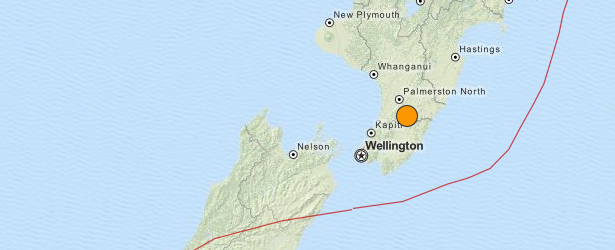
A very strong earthquake with recorded magnitude of 6.2 (GeoNet) struck New Zealand's North Island at 03:52 UTC on January 20, 2014 (15:52 local time). USGS measured depth of 28 km, GeoNet measured depth of 33 km.
Epicenter was located approximately 115 km northeast of Wellington.
GeoNet is reporting that the quake was felt strongly in both islands, and as of 20:30 local time they had received over 8000 felt reports from the public, with multiple reports of damage.
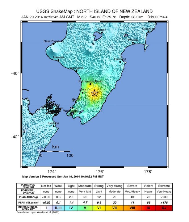
"Maximum peak ground acceleration recorded by GeoNet instruments is about one quarter of the acceleration due to gravity (0.26 g). This measurement was recorded in Woodville. Relatively strong shaking was also recorded on the Kapiti Coast (e.g. up to 0.2 g in Paraparaumu) whereas accelerations recorded in Wellington city were less than 0.05 g. In comparison, ground motions recorded in Wellington during the recent Cook Strait earthquakes ranged up to 0.26g.
We have calculated aftershock probabilities. In the first week of the aftershock sequence, we estimate that there will be about 23 aftershocks of magnitude 4.0 to 4.9, with the final number probably falling between 14 and 33. We also estimate about 2 aftershocks of magnitude 5.0 to 5.9 with the final number probably between 0 and 5.
As with any aftershock sequence, we cannot rule out the possibility of occurrence of future larger earthquakes. The after shock region considered includes most of the lower North Island.
GNS Science and GeoNet are also planning to deploy more seismometers to the region to supplement the permanent GeoNet network. The seismology team at GNS Science is also attempting to understand the earthquakes in the context of recent and ongoing seismicity. Specifically, efforts are aimed at comparing the current earthquakes with a sequence of events that occurred to the north of Eketahuna in the early 1990s. We are also considering possible links to the ongoing Kapiti slow slip event.
The likelihood of a larger triggered event in the coming weeks is minor. However, it is possible and we should all take this opportunity to review our earthquake emergency plans." (GeoNet)
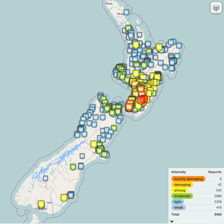
Public felt reports as of 20:30 local time. Source: GeoNet
The earthquake resulted from northeast-southwest oriented normal faulting 175 km to the west of the Hikurangi Trench, where the Pacific plate subducts westward beneath the North Island. At the latitude of this event, the Pacific plate moves towards the west-southwest with respect to the Australia plate at a rate of approximately 42 mm/yr. The faulting character, location and depth of this earthquake indicate it is an intraplate event either within Australia plate crust above the subducting Pacific plate, or within the interior of subducted Pacific slab, rather than a plate boundary event on the subduction zone thrust interface.
New Zealand experiences fairly frequent moderate-sized earthquakes; the region within 200 km of the January 20, 2014 event has experienced 35 earthquakes of M 5.5 or larger over the past century. The 2014 event is just a few kilometers to the east of a M 7.3 earthquake in March of 1934, and approximately 40 km southwest of two M 6.2 and 6.4 earthquakes near Dannevirke in March and May of 1990, respectively. The 1990 events did not cause significant damage or fatalities. (USGS)
Featured image: USGS
On Sunday early morning,January 19,2014,at 3:34 am hit Northern Hungary and Southern Slovakia,earthquake with magnitude 4.4. Shortly after followed smaller aftershock.It had scarried many Hungarians,including my sister which live from the epicentre only 16 km,nearby Balassagyarmat.There was a minor damage to buildings.The quake was felt also in Budapest. I had experienced two quakes in Seattle,WA,6.6 and one in 2001,Feb.28,7.2 on Richter scale,and I know how scarry human being gets during a quake of this magnitudes…Slovakia has numerous thermal waters and pools and lies on seismic area with minor quakes recorded,so far…It appears that Central Europe has a small tectonic plate rift…My sister told me,she was up at that moment of the quake and all was suddenly shaking in her new house,flower pot swinging wildly…I remeber from the 60's up to the late 90's,there were ZERO quakes in that are,but in last 20-30 years that area had about 3-4 minor quakes…One can only wonder what had triggered this quake activity there…
whoomp…!!! there it is