Steam plume observed at Gaua volcano, Vanuatu
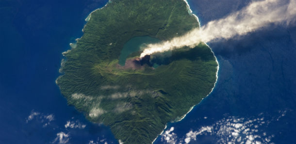
Gaua, also known as Santa Maria Island, is part of the Vanuatu Archipelago, a group of volcanic islands in the South Pacific Ocean. Just 20 kilometers (12 miles) in diameter, Gaua Island is actually the exposed upper cone and summit of a stratovolcano that is 3,000 meters (10,000 feet) high and 40 kilometers (25 miles) in diameter. Most of the volcano is submerged beneath the Pacific Ocean, while 797 meters is above the sea level. The caldera (a giant crater of 6×8 km) is partly occupied by Lake Letas and by the Mount Gharat, a historically active cinder cone located along the southwest flank of a collapsed summit caldera. Gaua is one of several volcanoes monitored by the Vanuatu Geohazards Observatory.
The most recent report of an eruptive activity at Gaua was a steam plume observed from an aircraft on April 29, 2013. Up to 1962 no eruptions had been recorded and the volcano, covered by a dense rainforest, was probably in a solfataric stage. In 1962 this long period of dormancy ended and a new crater opened on the SE flank of the cone. Explosions with frequent associated ash columns were reported nearly every year until 1977. Since April 1991, strong continuous degassing has occurred at the SE crater, an evidence that magma is not far from surface.
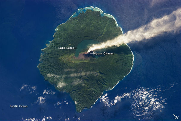
This photograph records subsequent steam emissions observed on May 31, 2013, by an astronaut on the International Space Station.The dark blue-green waters of Lake Letas, formed within the caldera, are visible at image center. The majority of Santa Maria Island is covered in green vegetation, with areas directly west and south of Mount Gharat covered with grey ash deposits. Patchy cloud cover is visible to the west and south, but is easily distinguished from the steam plume by its linear nature and brighter tone. (Credit: NASA/JSC Gateway to Astronauth Photography of Earth)
Source: Earth Observatory
Astronaut photograph ISS036-E-5647 was acquired on May 31, 2013, with a Nikon D3S digital camera using a 400 mm lens, and is provided by the ISS Crew Earth Observations experiment and the Image Science & Analysis Laboratory, Johnson Space Center. The image was taken by the Expedition 36 crew. The image has been cropped and enhanced to improve contrast, and lens artifacts have been removed. The International Space Station Program supports the laboratory as part of the ISS National Lab to help astronauts take pictures of Earth that will be of the greatest value to scientists and the public, and to make those images freely available on the Internet. Additional images taken by astronauts and cosmonauts can be viewed at the NASA/JSC Gateway to Astronaut Photography of Earth. Caption by William L. Stefanov, Jacobs/JETS at NASA-JSC.
i wish al be there
oh sad news for the people of this beautiful archipels