Massive earthquake M 7.4 strikes Champerico, Guatemala
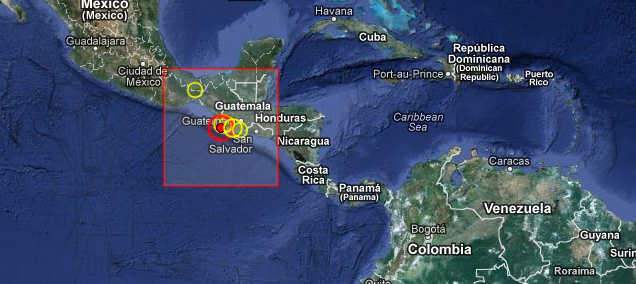
Massive and deadly earthquake with recorded magnitude 7.4 hit Guatemala on November 7, 2012 at 16:35 UTC according to USGS. Epicenter was located 24 km (14 miles) S of Champerico, Guatemala and 61 km (37 miles) SSW of San Sebastian, Guatemala at coordinates 14.083°N, 91.916°W. Recorded depth was 41.6 km (25.9 miles) according to USGS.
EMSC is reporting a 7.4 magnitude earthquake and depth of 30 km.
It was 10:35 a.m. local time, the midst of the work day; the epicenter was about 32 km (20 miles) out of the coast.
The Guatemalan Instituto Nacional de Sismología reports a Magnitude of 7.2 at a depth and mentions a MMI of V at many Guatemalan locations. The earthquake was well felt at Guatemala, Jalapa, Jutiapa, Alta Verapaz, Quetzaltenango, Suchitepéquez, Zacapa, Escuintla and Quiché.
Guatemalan president Otto Pérez Molina has called the Red Alert in the country. It was felt in neighboring Mexico and El Salvador, sparking a tsunami alert on the Salvadoran coast and evacuations from offices, homes and schools as far north as Mexico City.
Damage was reported in all but one of Guatemala’s 22 states and shaking felt as far away as Mexico City, 600 miles (965 kilometers) to the northwest.

This was the strongest earthquake to hit Guatemala since a 1976 temblor that killed 23,000.
Tsunami evaluation
Sea level readings indicate a tsunami was generated. It may have been destructive along coasts near the earthquake epicenter. For those areas – when no major waves are observed for two hours after the estimated time of arrival or damaging waves have not occurred for at least two hours then local authorities can assume the threat is passed. Danger to boats and coastal structures can continue for several hours due to the continuing sea level changes and rapid currents. As local conditions can cause a wide variation in tsunami wave action the all clear determination must be made by local authorities. No tsunami threat exists for other coastal areas in the pacific although some other areas may experience small non-destructive sea level changes lasting up to several hours. (PTWC)
Volcanic activity
In September 2012, tens of thousands of residents were evacuated after a Guatemala’s “Volcán de Fuego,” or Fire Volcano erupted and began to spew large amounts of ash in the air (September 13, 2012), covering the tourist town of Antigua. Just 8 days earlier there was a massive subduction earthquake measuring M 7.6 in Costa Rica (September 5, 2012) at 14:42 UTC.
INSIVUMEH reported that during November 1-2 white fumarolic plumes from Fuego rose 100 m and drifted SW. Explosions ejected incandescent material 100 m above the lava dome, and produced ash plumes that rose almost 500 m and drifted 10 km SW. A lava flow traveled 350 m SSW down the Ceniza drainage. On November 3 heavy rain caused lahars that traveled down the Ceniza drainage, carrying tree branches and 2-m-wide blocks. During November 3-6 explosions generated ash plumes that rose 150-450 m and drifted W and NW. Incandescent material was ejected 100 m above the crater and generated avalanches near the crater. A lava flow traveled 600-800 m down the Ceniza drainage, producing incandescent block avalanches that reached vegetated areas.
Updates:
Update 12:13 UTC, November 8, 2012 (ER)
Latest official toll, at 00:00 local Guatemala time:
- 50 people killed
- 21 missing
- 150 injured
- 17000 people affected who need aid in one or another way
- Most affected sectors in the country : San Marcos, Quetzaltenango, Sololá and Totonicapán
- 29 aftershocks in between M4.2 and M4.6 were registered in between the occurrence of the mainshock and midnight local time
- The hardest hit areas are build on softer soil than the other areas who suffered the earthquake. Among this softer soil, a lot of non consolidated ash from the close-by volcanoes. Waves are propagated a lot better is this kind of soil than on rocky older sediments. How to protect your house against it : following the guidelines of earthquake resistant building would do the job
- Guatemala lies along a range of active volcanoes, and is vulnerable to severe earthquakes. It is one of the region’s poorest and many buildings don’t comply with seismic standards.
Update 07:20 UTC, November 8, 2012 :
By official reports 48 people died, 23 are missing. 155 people were injured and 17 000+ affected. At least 135 houses have been destroyed with additional ones damaged.
The deaths occurred in San Pedro Sacatepequez, adjacent to San Marcos through a combination of landslides through shaking, and building collapses.
Officials said most of 100 missing were from San Marcos, where people farm corn and herd cattle, mostly for their own survival.
Hospital officials in San Marcos said they had received 150 injured.
Update 22:55 UTC, November 7, 2012 :
The number of fatalities is rising very fast. By some reports there were 63 deaths so far, 25 people under rumble and more than 150 people missing.
Electricity is still cut off for 10000 people at Champerico, near the epicenter. There are no telecommunications at the hard hit San Marcos area.
| Magnitude | 7.4 |
|---|---|
| Date-Time |
|
| Location | 14.083°N, 91.916°W |
| Depth | 41.6 km (25.9 miles) |
| Region | OFFSHORE GUATEMALA |
| Distances | 24 km (14 miles) S of Champerico, Guatemala 56 km (34 miles) SSW of Retalhuleu, Guatemala 61 km (37 miles) SSW of San Sebastian, Guatemala 61 km (37 miles) SSE of Suchiate, Mexico |
| Location Uncertainty | horizontal +/- 15 km (9.3 miles); depth +/- 9 km (5.6 miles) |
| Parameters | NST=635, Nph=635, Dmin=244.9 km, Rmss=1.17 sec, Gp= 58°, M-type=(unknown type), Version=7 |
| Source |
|
| Event ID | usb000dlwm |


Tectonic summary by USGS
The November 7, 2012 M 7.4 earthquake south of Champerico, Guatemala occurred as a result of thrust faulting on or near the subduction zone interface between the subducting Cocos plate and the overlying Caribbean and North America plates, near their triple junction. At the latitude of this earthquake, the Cocos plate moves north-northeast with respect to the Caribbean and North America plates at a velocity of approximately 70-80 mm/yr, and subducts beneath Central America at the Middle America Trench.
Over the past 40 years, the region within 250 km of the November 7 earthquake has experienced 50 earthquakes with M 6 or greater; two of these were larger than M 7. The first was a M 7.1 in December of 1983, in approximately the same location as the November 7 event, and resulted in no documented fatalities. The second had a magnitude of M 7.2, and struck a region just over 100 km to the northwest offshore Mexico in September 1993. There was one known fatality associated with the 1993 event. A M6.8 earthquake in October of 1979, 120 km to the east-southeast of the November 7 earthquake, resulted in 7 fatalities in Guatemala.
Aftershocks – World wide events list since M 7.4 earthquake
Update time = Thursday, November 8, 2012 at 15:27 UTC (Source: USGS)
November 8, 2012
| MAG | UTC DATE-TIME y/m/d h:m:s |
LAT deg |
LON deg |
DEPTH km |
Region |
|---|---|---|---|---|---|
| 2.6 | 2012/11/08 13:50:05 | 18.408 | -66.419 | 64.0 | PUERTO RICO |
| 4.6 | 2012/11/08 12:46:07 | 36.306 | 71.202 | 51.4 | HINDU KUSH REGION, AFGHANISTAN |
| 2.9 | 2012/11/08 09:58:28 | 45.029 | -124.127 | 36.2 | OFFSHORE OREGON |
| 4.4 | 2012/11/08 09:45:06 | 38.380 | 46.785 | 10.1 | NORTHWESTERN IRAN |
| 4.3 | 2012/11/08 09:10:33 | -2.929 | 128.030 | 28.1 | CERAM SEA, INDONESIA |
| 3.4 | 2012/11/08 08:20:41 | 17.412 | -68.859 | 76.0 | DOMINICAN REPUBLIC REGION |
| 4.3 | 2012/11/08 08:16:49 | 14.348 | -92.496 | 35.0 | OFFSHORE CHIAPAS, MEXICO |
| 5.1 | 2012/11/08 07:39:44 | -14.711 | 167.159 | 114.1 | VANUATU |
| 4.4 | 2012/11/08 07:13:06 | -18.150 | -178.063 | 624.4 | FIJI REGION |
| 2.6 | 2012/11/08 07:02:16 | 19.676 | -64.309 | 43.0 | VIRGIN ISLANDS REGION |
| 2.8 | 2012/11/08 06:24:34 | 58.965 | -154.372 | 114.4 | ALASKA PENINSULA |
| 4.5 | 2012/11/08 06:24:10 | -32.742 | -71.399 | 38.8 | VALPARAISO, CHILE |
| 3.1 | 2012/11/08 05:46:11 | 19.646 | -66.355 | 9.0 | PUERTO RICO REGION |
| 2.5 | 2012/11/08 05:27:52 | 18.057 | -66.933 | 21.0 | PUERTO RICO |
| 4.4 | 2012/11/08 05:20:41 | 4.577 | 125.995 | 148.6 | KEPULAUAN SANGIHE, INDONESIA |
| 4.7 | 2012/11/08 04:27:16 | -55.951 | -27.427 | 83.0 | SOUTH SANDWICH ISLANDS REGION |
| 5.1 | 2012/11/08 03:24:29 | -36.277 | 53.365 | 10.0 | SOUTH INDIAN OCEAN |
| 4.7 | 2012/11/08 03:23:37 | -18.622 | 168.629 | 103.2 | VANUATU |
| 2.9 | 2012/11/08 02:31:08 | 19.492 | -155.219 | 5.8 | ISLAND OF HAWAII, HAWAII |
| 4.8 | 2012/11/08 02:27:15 | 14.092 | -92.569 | 35.3 | OFFSHORE CHIAPAS, MEXICO |
| 4.5 | 2012/11/08 02:26:40 | 14.022 | -92.756 | 35.5 | OFFSHORE CHIAPAS, MEXICO |
| 2.6 | 2012/11/08 02:22:19 | 61.388 | -146.276 | 25.2 | SOUTHERN ALASKA |
| 4.9 | 2012/11/08 02:20:38 | 14.195 | -91.971 | 35.4 | OFFSHORE GUATEMALA |
| 2.7 | 2012/11/08 02:14:20 | 62.436 | -152.384 | 0.3 | CENTRAL ALASKA |
| 2.9 | 2012/11/08 02:05:00 | 60.021 | -143.083 | 40.0 | SOUTHERN ALASKA |
| 6.3 | 2012/11/08 02:01:51 | 49.185 | -128.528 | 16.6 | VANCOUVER ISLAND, CANADA REGION |
| 2.8 | 2012/11/08 01:06:44 | 60.469 | -147.732 | 10.3 | SOUTHERN ALASKA |
| 3.8 | 2012/11/08 00:49:46 | 17.656 | -68.899 | 112.0 | DOMINICAN REPUBLIC REGION |
| 3.5 | 2012/11/08 00:44:48 | 19.623 | -64.383 | 25.0 | VIRGIN ISLANDS REGION |
November 7, 2012
| MAG | UTC DATE-TIME y/m/d h:m:s |
LAT deg |
LON deg |
DEPTH km |
Region |
|---|---|---|---|---|---|
| 5.6 | 2012/11/07 23:42:17 | -8.663 | 148.046 | 96.5 | EASTERN NEW GUINEA REG, PAPUA NEW GUINEA |
| 2.5 | 2012/11/07 23:40:19 | 66.392 | -141.588 | 23.3 | NORTHERN ALASKA |
| 5.1 | 2012/11/07 22:42:49 | 13.907 | -92.225 | 35.1 | OFFSHORE GUATEMALA |
| 4.9 | 2012/11/07 22:41:33 | -37.523 | -72.914 | 39.5 | BIO-BIO, CHILE |
| 2.9 | 2012/11/07 21:55:15 | 60.532 | -152.792 | 118.5 | SOUTHERN ALASKA |
| 4.7 | 2012/11/07 21:19:26 | -22.408 | -68.476 | 112.2 | ANTOFAGASTA, CHILE |
| 5.0 | 2012/11/07 19:55:35 | 14.018 | -92.173 | 35.1 | OFFSHORE GUATEMALA |
| 2.6 | 2012/11/07 19:11:27 | 18.711 | -66.357 | 104.0 | PUERTO RICO REGION |
| 2.5 | 2012/11/07 18:07:49 | 57.707 | -154.451 | 50.4 | KODIAK ISLAND REGION, ALASKA |
| 5.0 | 2012/11/07 17:04:05 | 13.903 | -91.791 | 35.0 | OFFSHORE GUATEMALA |
| 4.7 | 2012/11/07 16:57:08 | 14.102 | -92.361 | 35.0 | OFFSHORE GUATEMALA |
| 7.4 | 2012/11/07 16:35:50 | 14.083 | -91.916 | 41.6 | OFFSHORE GUATEMALA |
Featured image: M 7.4 earthquake, Guatemala. Credit EMSC.
[…] earthquake is the aftershock of massive M 7.4 earthquake that struck the same area few days ago, on November 7. Already damaged infrastructure […]
Our coastal EQ alarm system in my sleepy shoreline hamlet is synchronized with EQs that take place along the Pacific coast. A sense of dread (today) comes over me each time our warning system sounds off knowing a large EQ has taking place on the West coast.
I have noticed an uptick in town meetings that include, the fire department, police department and The Red Cross as they prepare for a potential tsunami. If a tsunami were to hit this town or for that matter any coastal town the choke-points for traffic will be North/South interstate 101 and 26 East.
Let’s face it, people will not have enough time to evacuate properly and will more than likely succumb to drowning as they panic for high ground.