M 7.7 hit Haida Gwaii region – Tsunami warning for British Columbia, Alaska, Hawaii
Strong magnitude 7.7 earthquake hit Haida Gwaii region, Canada at 03:04 UTC on October 28, 2012.
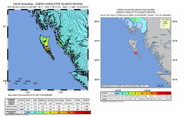
Epicenter was located 25 miles (40 kilometers) south of Sandspit, British Columbia on the Haida Gwaii archipelago, formerly known as the Queen Charlotte Islands, and 139 km (86 miles) S of Masset, Canada (52.769°N, 131.927°W) at depth of 17.5 km (10.9 miles) according to USGS.
EMSC is also reporting magnitude 7.7 earthquake with depth of 17 km.
GDACS reported that this earthquake is expected to have a medium humanitarian impact based on the magnitude and the affected population and their vulnerability. About 200 people are living within 100 km radius.
It was followed by numerous aftershocks – 5.8, 4.8, 5.1, 4.6, 4.7 and 4.5.
Canada (NRCAN) reported M7.7 earthquake in the Haida Gwaii Region, followed by numerous aftershocks.
A small tsunami has been recorded on a deep ocean pressure sensor.


Emergency Management BC and West Coast and Alaska Tsunami Warning Center issued TSUNAMI WARNING for the coastal areas of British Columbia and Alaska from the north tip of Vancouver Island, BC to Cape Decision, Alaska, located 85 miles SE of Sitka. People in low-lying coastal areas should be alert to instructions from their local emergency officials.
– Advisory the north tip of Vancouver Island, British Columbia – the Washington-British Columbia border Issued at: Sun Oct 28 2012 06:02:58 GMT+0100 (Central European Standard Time)
 –
–  –
– 2012-10-28 08:26 UTC
– Tsunami warning remains in effect for Hawaii (expected arrival time 10:28 PM)
2012-10-28 07:54 UTC
THE ADVISORY IS CANCELLED FOR SE ALASKA AND CONTINUES FOR BRITISH COLUMBIA SOUTHERN OREGON AND NORTHERN CALIFORNIA.
2012-10-28 12:05 UTC
THE TSUNAMI WARNING IS NOW CANCELLED FOR THE STATE OF HAWAII.
A TSUNAMI ADVISORY IS ISSUED FOR THE STATE OF HAWAII EFFECTIVE AT 1254 AM HST.
…THE TSUNAMI ADVISORY IS CANCELED FOR THE COASTAL AREAS OF CALIFORNIA FROM GUALALA POINT CALIFORNIA/LOCATED 80
MILES NW OF SAN FRANCISCO/ TO THE OREGON-CALIFORNIA BORDER…
THE TSUNAMI THREAT HAS DIMINISHED FOR ALASKA/ BRITISH COLUMBIA/WASHINGTON/ OREGON OR CALIFORNIA. HOWEVER… SOME AREAS MAY EXPERIENCE NON-DAMAGING SEA LEVEL CHANGES. AS LOCAL CONDITIONS CAN CAUSE A WIDE VARIATION IN TSUNAMI WAVE ACTION THE ALL CLEAR DETERMINATIONS MUST BE MADE BY LOCAL AUTHORITIES.


The maximum tsunami wave height is in Pacofi, Canada. This height is estimated for October 27 2012 03:10:00 UTC. About 2000 people live within area of 100km from the epicenter.
The U.S. Coast Guard in Alaska said it was trying to warn everyone with a boat on the water to prepare for a potential tsunami.

Natural Resources Canada said in a statement that a major earthquake was felt across much of north and central British Columbia but that there were no immediate reports of damage.
USGS PAGER issued yellow alert level for economic losses – some damage is possible and the impact should be relatively localized. Estimated economic losses are less than 1% of GDP of Canada. Past events with this alert level have required a local or regional level response. Green alert level for shaking-related fatalities – there is a low likelihood of casualties.
This earthquake is expected to have a medium humanitarian impact based on the magnitude and the affected population and their vulnerability.

Earthquake background
From northern Vancouver Island, to the Queen Charlotte Islands, the oceanic Pacific plate is sliding to the northwest at about 6 cm/year relative to North America. The boundary between these two giant plates is the Queen Charlotte fault – Canada’s equivalent of the San Andreas fault. Canada’s largest historical earthquake – a magnitude 8.1, occurred along this fault on August 22, 1949. This earthquake, larger than the 1906 San Francisco earthquake, caused nearly a 500-km-long segment of the Queen Charlotte fault to break.

Mainshock and aftershocks
Update time = Sunday, October 28, 2012 at 8:44:14 UTC 2012, Source: USGS
| MAG | UTC DATE-TIME y/m/d h:m:s |
LAT deg |
LON deg |
DEPTH km |
Region |
|---|---|---|---|---|---|
| 3.9 | 2012/10/28 07:47:03 | 33.693 | -116.816 | 17.7 | SOUTHERN CALIFORNIA |
| 5.0 | 2012/10/28 07:25:22 | 52.270 | -131.493 | 10.6 | QUEEN CHARLOTTE ISLANDS REGION |
| 4.9 | 2012/10/28 07:16:38 | 52.775 | -132.456 | 11.4 | QUEEN CHARLOTTE ISLANDS REGION |
| 4.6 | 2012/10/28 07:12:14 | 52.109 | -132.221 | 10.0 | QUEEN CHARLOTTE ISLANDS REGION |
| 5.0 | 2012/10/28 06:16:53 | 52.268 | -131.212 | 11.5 | QUEEN CHARLOTTE ISLANDS REGION |
| 4.7 | 2012/10/28 06:15:15 | 10.337 | 126.656 | 34.9 | PHILIPPINE ISLANDS REGION |
| 4.5 | 2012/10/28 05:51:17 | 52.815 | -132.714 | 10.3 | QUEEN CHARLOTTE ISLANDS REGION |
| 4.2 | 2012/10/28 05:47:09 | 52.429 | -131.451 | 10.1 | QUEEN CHARLOTTE ISLANDS REGION |
| 4.1 | 2012/10/28 05:38:38 | 51.786 | -132.312 | 10.1 | QUEEN CHARLOTTE ISLANDS REGION |
| 4.3 | 2012/10/28 05:21:37 | 52.139 | -131.571 | 10.0 | QUEEN CHARLOTTE ISLANDS REGION |
| 4.3 | 2012/10/28 05:15:13 | 52.499 | -132.222 | 10.1 | QUEEN CHARLOTTE ISLANDS REGION |
| 4.5 | 2012/10/28 05:02:50 | 52.409 | -132.165 | 10.3 | QUEEN CHARLOTTE ISLANDS REGION |
| 4.3 | 2012/10/28 04:54:46 | 52.403 | -132.439 | 10.1 | QUEEN CHARLOTTE ISLANDS REGION |
| 4.7 | 2012/10/28 04:41:05 | 52.592 | -132.670 | 10.0 | QUEEN CHARLOTTE ISLANDS REGION |
| 4.6 | 2012/10/28 04:33:51 | 52.906 | -133.120 | 10.0 | QUEEN CHARLOTTE ISLANDS REGION |
| 5.1 | 2012/10/28 04:25:17 | 52.019 | -133.370 | 10.1 | QUEEN CHARLOTTE ISLANDS REGION |
| 2.9 | 2012/10/28 04:12:12 | 17.424 | -68.914 | 74.0 | DOMINICAN REPUBLIC REGION |
| 3.1 | 2012/10/28 04:00:35 | 35.466 | -96.581 | 4.9 | OKLAHOMA |
| 4.8 | 2012/10/28 03:52:25 | 52.199 | -131.986 | 10.9 | QUEEN CHARLOTTE ISLANDS REGION |
| 5.1 | 2012/10/28 03:08:54 | 10.484 | 92.735 | 64.5 | ANDAMAN ISLANDS, INDIA REGION |
| 7.7 | 2012/10/28 03:04:11 | 52.769 | -131.927 | 17.5 | QUEEN CHARLOTTE ISLANDS REGION |
| 5.3 | 2012/10/28 02:43:10 | 10.484 | 126.694 | 14.8 | PHILIPPINE ISLANDS REGION |
| 4.9 | 2012/10/28 02:35:10 | 10.469 | 126.766 | 14.9 | PHILIPPINE ISLANDS REGION |
| 4.5 | 2012/10/28 02:31:27 | 55.543 | 162.471 | 8.7 | NEAR THE EAST COAST OF KAMCHATKA, RUSSIA |
| 4.8 | 2012/10/28 01:53:12 | 10.570 | 126.805 | 15.0 | PHILIPPINE ISLANDS REGION |
| 4.9 | 2012/10/28 01:43:15 | 10.569 | 126.879 | 15.2 | PHILIPPINE ISLANDS REGION |
| 4.6 | 2012/10/28 01:38:20 | 55.753 | 162.323 | 12.2 | NEAR THE EAST COAST OF KAMCHATKA, RUSSIA |
| 2.9 | 2012/10/28 00:34:23 | 19.166 | -66.438 | 52.0 | PUERTO RICO REGION |
Livestream – Hawaii News – LIVE

No love for the Icelandic activity taking place in the last ten days with over 100 EQs per day no greater than 3 on the richter scale. Millions are distracted and for obvious reasons by hurricane Sandy as many ride the storm out on the East coast.
This similar event reminds me of the Canary Islands and the thousands of tremors that took place in a short period of time as the ocean spewed volcanic mud near the islands as a result of plate movement providing relief.
Meanwhile British Columbia on the Pacific coast is having EQ tantrums at 6-7 seismic levels as buoys go into event mode along the Pacific coast. I have noticed an uptick in Red Cross, fire department and police meetings being conducting in my sleepy hamlet with large banners and loud-speaker announcements stressing the three steps of tsunami evacuation.
I am about 50 yards away from the Pacific ocean. Within the past few weeks I have noticed low frequency rumbles and sounds that reverberate in all directions day/night and I assumed it was salt water pounding against coastal land barriers.
I combed the beach the other day and found these barriers that could possibly create low frequency rumbles by water against rocks or a wall and discovered that at this time of year the tides are too low.
As I spoke with a friend the other day we both experienced the same sound and rumble. I asked her what she thought it could be and her reply was “it’s not water crashing against rocks or land mass” and she left at that.
As more and more EQs ratchet up along the coastlines, so do the small amount of people preparing for an exodus away from the ocean, but I truly believe many will not heed to the early warnings.