New official image of Louisiana sinkhole shows significant growth – heavy odour reported
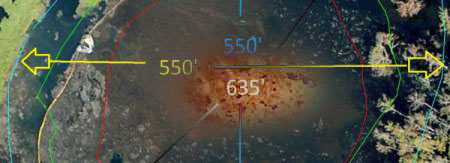
An new official map of the Louisiana sinkhole dimensions was uploaded to the Assumption Parish website on October 14, 2012:
Red Line: August 19, 2012
Green Line: September 21, 2012
Blue Line: October 14, 2012
Yellow line is oil boom

The original image can be found here. ENENEWS has interesting comparison of it with enhanced image:

LEAN analysis of air samples in the Bayou Corne/Grand Bayou area
As the sinkhole developed, the Bayou Corne/Grand Bayou community began complaining of odors and associated health impacts. Louisiana Environmental Action Network (LEAN) developed an Odor and Symptom Log For Use in Association with the Bayou Corne Incident and posted the – Odor and Symptom Log available online here.
Analysis of air samples in the Bayou Corne/Grand Bayou area by the Louisiana Department of Environmental Quality demonstrated that the concentrations of toxic chemicals in the air, including Volatile Organic Compounds such as Benzene, Toluene, Ethyl Benzene and Xylene, were below the Louisiana Ambient Air Standards. However, though the concentrations of toxic chemicals were below acceptable standards, health symptoms continue to be experienced and reported by community members. Read more about it here – LEAN.
Helicopter flyover on October 11, 2012
On October 11, 2012, photographer Jeffrey Dubinsky took a flight for LEAN and LMRK over the Bayou Corne sinkhole. After the flight, which was generously provided by Southwings, Jeffrey commented on the intense petroleum fumes experienced while flying over the sinkhole area.
“I will say the odor was the heaviest and strongest I have ever experienced in all my time in Louisiana. Perhaps even worse still was that the odor was hovering directly over the community… I have no idea whatsoever how the workers can tolerate being anywhere near it.”
View all photos from the flyover here.

Our previous reports on Louisiana sinkhole:
1. Residents of Assumption Parish (US) report earth tremors and venting streams of natural gas surfacing the waterways
2. Louisiana sinkhole – fears of radioactivity and gas explosion as sinkhole gets bigger
3. Elevated levels of radioactive elements found at Louisiana sinkhole site
Thoughts and prayers are with you all in sinkhole area.
Workers can stand being around it because jobs are scarce in most of Louisiana.
obvious…
i should say job openings not jobs
Looking for any info regarding the meteor which reportedly crashed down in that area on October 15th,2012
@ S. Rosenorn,
Watch the video and study the impact area. The article and MSM/news report claims the site to be an explosion at Camp Minden which would lead you to believe military munitions.
http://www.kltv.com/story/19828119/authorities-investigate-loud-boom
There are some radar 2D/3D renderings at 10kft (1 kilofoot = 1,000ft) of an object somewhat round captured on radar between 5-7kft as it presumably impacted in the Camp Minden area.
Link. Be sure to scroll down and check out the 3D rendering and 12.31.2010 bird die-off C.G.I. rendering possible meteor impact in Beebe, Arkansas at about the same altitude.
http://fromthetrenchesworldreport.com/meteorite-impacts-earth-in-minden-louisiana-media-and-government-cover-it-up/23890/
Here’s another link for global meteor impacts.
http://lunarmeteoritehunters.blogspot.com/
As the hole gets bigger Im sure Obama will blame the ‘previous adminstration”.
Trying to understand the action of officals is useless as far as anyone can see .
Following the $$ signs in their eyes is easier …
Are there at lot of “mineral right holders” in the area? I think they want the southern states for their own pockets.
Are they making the the disaster on purpose? So they can get the gas & oil and have a toxic (rad-waste) dump without being hindered by … people??
There is no explanation for the plain foot-dragging by officials.