Two volcanic eruptions at Mount Gamalama, Indonesia – alert level 3 of 4
Two separate explosions occurred at Gamalama volcano on Ternate Island, Indonesia on September 16, 2012 at 13.22 and 14.15 local time. Volcano Discovery reported that the eruption followed an increase in seismic activity and triggered PVMBG to raise the alert level to 3 (out of 4) “Siaga”. According to the newspaper Liputan 6 people saw an ash plume rise but have not heard the explosion.
State volcanologist Kristianto said slow-moving red lava was visible at the peak of the eruption Monday. Villages have been blanketed with thick ash but no evacuations have been ordered.
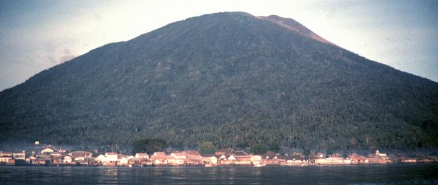
Gamalama (Peak of Ternate) is a near-conical stratovolcano that comprises the entire island of Ternate off the western coast of Halmahera and is one of Indonesia’s most active volcanoes.
An eruption prior to this weekend’s occurred On December 4, 2011 when Mount Gamalama ejected material up to 2,000 meters into the air. Thousands of residents in nearby Ternate City fled due to ash and dust particles raining down on the town. By December 27th 4 people have died and dozens were injured from debris falls (lahar). Some people were panicking, but the situation remained otherwise calm in Ternate.
“Lahar” is an Indonesian word that describes volcanic mudflows or debris flows. Lahars have the consistency, viscosity and approximate density of concrete: fluid when moving, solid at rest. Lahars can vary in size and speed. Small lahars less than a few meters wide and several centimeters deep may flow a few meters per second. Large lahars hundreds of meters wide and tens of meters deep can flow several tens of meters per second: much too fast for people to outrun.

The island of Ternate was a major regional center in the Portuguese and Dutch spice trade for several centuries, which contributed to the thorough documentation of Gamalama’s historical activity (volcano.si.edu). Three cones, progressively younger to the north, form the summit of Gamalama, which reaches 1715 m. Several maars and vents define a rift zone, parallel to the Halmahera island arc, that cuts the volcano. Eruptions, recorded frequently since the 16th century, typically originated from the summit craters, although flank eruptions have occurred in 1763, 1770, 1775, and 1962-63.
Featured image: Jack Lockwood, 1980 (U.S. Geological Survey)
i feel you my science teacher is making me do a project like that to so hope you do good
my techer is makeing me do this progect its bornig god help me
[…] plume rise but have not heard the explosion. Read our earlier report on latest Gamalama eruption here.The small Soputan stratovolcano on the southern rim of the Quaternary Tondano caldera on the […]