Sanba became supertyphoon with gusts up to 305 km/h
Sanba has rapidly intensified over the past 24 hours. Typhoon Sanba has strengthened into a super typhoon, the equivalent of a Category 5 hurricane, according to The Joint Typhoon Warning Center (JTWC), which brings Sanba to the strongest tropical cyclone of the season status. Winds of 270 km/h (170 mph) are gusting within this storm as it moves north. It is expected to hit Okinawa as Category 3 storm.

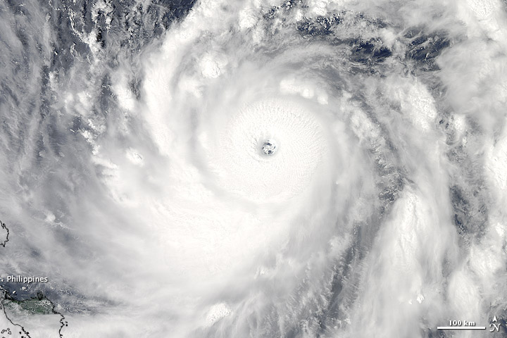
Sanba formed as a tropical depression over the western Pacific Ocean on September 10, 2012, and strengthened to a typhoon by September 12. On September 13, 2012, the U.S. Navy’s Joint Typhoon Warning Center (JTWC) reported that Sanba had maximum sustained winds of 250 km/h (135 knots) and gusts up to 305 km/h (165 knots).

Sanba is forecast to interact with the baroclinic zone and will begin extra-tropical transition in the 72 hours period. The system will accelerate poleward, weaken rapidly due to strong vertical wind shear and land interaction and is forecast to complete extra-tropical transition in 120 hours period.

Super typhoon Sanba poses a growing threat to southwestern Japan and South Korea.
Satellite Animations
- Storm-Centered Infrared (MTSAT; NOAA/SSD)
- Storm-Centered Infrared (Aviation Color Enhancement) (MTSAT; NOAA/SSD)
- Storm-Centered Water Vapor (MTSAT; NOAA/SSD)
- Storm-Centered Visible (MTSAT; NOAA/SSD)
- Storm-Centered Visible (Colorized) (MTSAT; NOAA/SSD)
- Tropical West Pacific Infrared (MTSAT2; NOAA)
- Tropical West Pacific Enhanced Infrared (MTSAT2; NOAA)
- Tropical West Pacific Water Vapor (MTSAT2; NOAA)
- Tropical West Pacific Visible (MTSAT2; NOAA)

NASA image courtesy Jeff Schmaltz, LANCE MODIS Rapid Response Team at NASA GSFC. Caption by Michon Scott.
[…] The Watchers – Sanba became supertyphoon with gusts up to 305 km/h. […]