Two M 6.3+ earthquakes struck off the eastern coast of Greenland, two M 5.4+ Indian-Antartic Ridge
A strong earthquake with magnitude 6.6 (EMSC) hit off Jan Mayen Island, Norway in the Arctic Ocean on August 30, 2012 at 13:43 UTC. USGS reported it as M6.8. Recorded depth by USGS was 8.6 km and only 2 km by EMSC. Epicenter was located 93km NW of Olonkinbyen, Svalbard and Jan Mayen at 71.52 N; 10.61 W. There is substantial difference in EMSC and USGS data, EMSC recorded a strong earthquake prior to M6.6 just three minutes before… at 13:40 UTC a 6.3 magnitude earthquake hit the same region according to them. USGS had no mention on that one and EMSC later removed it.
Both however reported that at 13:51 a M5.2 aftershock was recorded, 24km E of Olonkinbyen, Svalbard and Jan Mayen.

44 people currently live on the small island of which the main export is gravel and also doubles as a telecommunications base for Norway. There has been reports of some damage and a rockslide, but no injuries among the people living there. The city closest to the quake is Akureyri, Iceland, with a population of around 17,500, located 709 kilometers (441 miles) southwest of the epicenter.
ER reports that today M6.6 is one of the largest Norwegian earthquakes on record. In 2008, a M6.2 was reported in Svalbard.
According to NORSAR “The largest earthquakes in historical times in Norway and surrounding offshore areas occurred in the Rana region in 1819, M 5.8, in the Vøring Basin in 1866, M 5.7, in the outer Oslofjord in 1904, M 5.4 and in the Viking Graben in 1927, M 5.3. The last earthquakes above M 5 include an M 5.3 event in the Vøring Basin in 1988, in an area with almost no earlier seismicity, and an M 5.2 event in the northeastern North Sea in 1989.”
The Oslofjord earthquake of 1904 is the best known earthquake causing damage in Norway. Further damage is yet to be confirmed as well as a possible tsunami caused by underwater landslide.

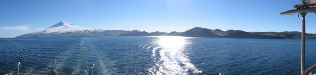
Jan Mayen Island is a volcanic island in the Arctic Ocean and part of the Kingdom of Norway. It is 55 km (34 mi) long (southwest-northeast) and 373 km2 (144 sq mi) in area, partly covered by glaciers (an area of 114.2 km (71.0 mi) around theBeerenberg). It has two parts: larger northeast Nord-Jan and smaller Sør-Jan, linked by an isthmus 2.5 km (1.6 mi) wide. It lies 600 km (370 mi) northeast of Iceland, 500 km (310 mi) east of central Greenland and 1,000 km (620 mi) west of theNorth Cape, Norway. The island is mountainous, the highest summit being the Beerenberg volcano in the north.
The Jan Mayen Microcontinent is a fragment of continental crust within the oceanic part of the western Eurasian Plate lying northeast of Iceland. At the onset of separation between the Greenland and Eurasian plates 55 million years ago, it formed part of the eastern margin of the Greenland Plate. Propagation of a new spreading center from the Reykjanes Ridge separated this microcontinent from the Greenland Plate. For a short period it formed a microplate, until the Aegir Ridge became inactive, after which it formed part of the Eurasian Plate. The island of Jan Mayen is a much younger feature, formed of volcanic rock, built up at the northernmost tip of the microcontinent.

Few hours before Grenlands M6.6, at 10:53 UTC a 5.4 magnitude (EMSC) earthquake struck at Western Indian-Antarctic Ridge. According to USGS magnitude of this one was 5.0 Both agencies agreed that the depth was at 10km! Forward one hour and at 12:18 UTC a 5.6 magnitude (EMSC) earthquake was recorded (5.4 according to USGS). Both agencies agreed that the depth of this one was 10 km too.


Featured image: coastline of Jan Mayen with the Beerenberg Volcano
How do I get back to the old USGS earthquake map as shown above in your article? I can get the US map like this from USGS, but they have switched to a real-time google map that I personally don’t find helpfull. I miss the animations too. Any information would be helpful. Thank you.
Yes, the same here. You can use old link, they warn that it isn’t regulary updated but I didn’t noticed. It was regulary updated by now.
Here is the link: http://earthquake.usgs.gov/earthquakes/recenteqsww/
Thank you~! I’ve missed it – has been a daily stop for years. Will miss the animations though. I could watch the loops several times and hope to discern a pattern. It was never boring. I’m sure you are no doubt aware of http://www.iris.edu/seismon/ … thanks again. Thank you to The Watchers – very informative blog.
Be Blessed~!
*´¨)
¸.•´¸.•*´¨) ¸.•*¨)
(¸.•´ (¸.• Scott
[…] Two 6.3 Quakes off Greenland https://watchers.news/2012/08/30/two-m6-3-earthquakes-struck-off-the-eastern-coast-of-gre… […]
I have been following this EXCELLENT web site for over a year. Thank you to whoever is the Web master of the Watchers and your on-line community. I work for NOAA so I appreciate the sensible – scientific measure to all your article choices. 11 days until 9-11 then the final 100 days till 12-21