Shallow 6.7 magnitude earthquake hit offshore Mauritius – Reunion region
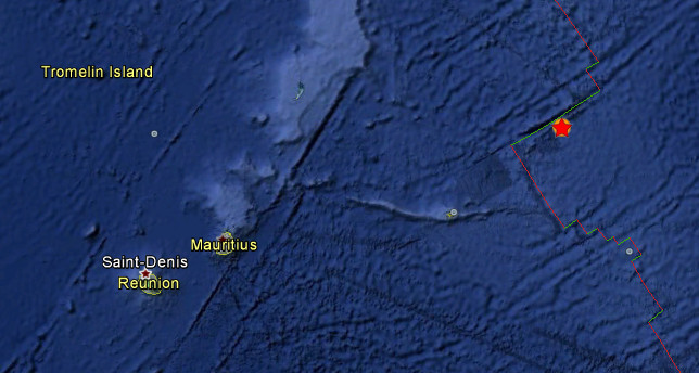
Shallow earthquake with magnitude 6.7 hit Mauritius – Reunion region on July 26, 2012 at 5:33 UTC according to USGS. Recorded depth was 9.8 km (6.1 miles). Epicenter was located far away from land, 387 km (240 miles) NE of Port Mathurin, Mauritius (17.593°S, 66.363°E). No tsunami was expected from this one.
This earthquake can have a low humanitarian impact based on the magnitude and the affected population and their vulnerability.
| Magnitude | 6.7 |
|---|---|
| Date-Time |
|
| Location | 17.593°S, 66.363°E |
| Depth | 9.8 km (6.1 miles) |
| Region | MAURITIUS – REUNION REGION |
| Distances | 387 km (240 miles) NE of Port Mathurin, Mauritius 388 km (241 miles) NE of Ile Rodrigues, Northern Mariana Islands 954 km (592 miles) ENE of Bel Air, Mauritius 955 km (593 miles) ENE of Centre de Flacq, Mauritius |
| Location Uncertainty | horizontal +/- 20.3 km (12.6 miles); depth +/- 4.2 km (2.6 miles) |
| Parameters | NST= 62, Nph= 62, Dmin=980.7 km, Rmss=1.56 sec, Gp= 72°, M-type=centroid moment magnitude (Mw), Version=7 |
| Source |
|
| Event ID | usb000bgdg |
This is third 6.4+ earthquake in last 24 hours. Earlier we saw 6.4 Simelue, Indonesia and 6.5 Solomon Islands, both at depth of 22 km.
After todays 6.7 in Mauritius followed 5.2 south of Fiji Islands at depth of 329 km and 4.9 North Island, New Zealand at depth of 32.9 km.
[…] Share this:TwitterFacebookEmailDiggLinkedInRedditStumbleUponTumblrPinterestPrintLike this:LikeBe the first to like this. This entry was posted in Earth Changes and tagged 6.7 Mag Earthquake, July 26 2012, Mauritius. Bookmark the permalink. ← Within Two Worlds by Brad Goldpaint […]