Global seismic unrest – Two moderate earthquakes offshore Northern California
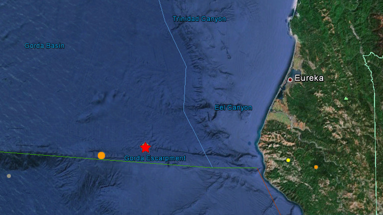
According to USGS a 5.1 magnitude earthquake hit offshore Northern California on July 21, 2012 at 1:52 UTC. Recorded depth was 10 km and epicenter located 108 km (67 miles) W (274°) from Petrolia, CA at 40.382°N, 125.559°W.
| Magnitude | 5.1 |
|---|---|
| Date-Time |
|
| Location | 40.382°N, 125.559°W |
| Depth | 10 km (6.2 miles) (poorly constrained) |
| Region | OFFSHORE NORTHERN CALIFORNIA |
| Distances |
|
| Location Uncertainty | horizontal +/- 2.7 km (1.7 miles); depth +/- 31.6 km (19.6 miles) |
| Parameters | Nph= 37, Dmin=104 km, Rmss=0.22 sec, Gp=256°, M-type=regional moment magnitude (Mw), Version=A |
| Source |
|
| Event ID | nc71819391 |

The second one struck the same area at 6:04 UTC with preliminary magnitude of 5.8 which was downgraded to 5.2 couple of hours later. Poorly constrained depth of this one was 0.6km. Epicenter was located 81 km (50 miles) W (279°) from Petrolia, CA at 40.430°N, 125.234°W.
| Magnitude | 5.2 |
|---|---|
| Date-Time |
|
| Location | 40.430°N, 125.234°W |
| Depth | 0.6 km (~0.4 mile) (poorly constrained) |
| Region | OFFSHORE NORTHERN CALIFORNIA |
| Distances |
|
| Location Uncertainty | horizontal +/- 1.8 km (1.1 miles); depth +/- 13.6 km (8.5 miles) |
| Parameters | Nph=151, Dmin=76 km, Rmss=0.57 sec, Gp=230°, M-type=regional moment magnitude (Mw), Version=6 |
| Source |
|
| Event ID | nc71819471 |

Earthquake-report.com had very interesting analysis of whats going on there:
While looking into the details about these earthquakes, we found a number of coincidences which may be realated to each other. The series started with a M4.0 earthquake at a depth of 10.1 km (6.3 miles) along the ridge fault in front of the Oregon coast. Nothing special as the stress in the part of the fault is generating regular earthquakes up to M6.0.
1 hour and 18 minutes later a more powerful M5.1 earthquake occurred along the same ridge fault (separating plates), bt this time more to the south in the Californian sector. The depth was set to 10 km or 6.2 miles but this is the usual depth which is set if the data are not accurate enough.
Finally (at least up to now) a M5.2 earthquake occurred at a depth of 0.6 km approx. in the same sector than the earlier M5.1 earthquake. The depth of the last M5.2 earthquake (even poorly constrained) is attracting our attention. We do not sea anything special on the sea floor except some stress scars and ridges (red lines on the three maps below).
There is certainly no proved relation in between the Oregon and California events, but if ER detects patterns, we like to share them with our readers.
Only few people at the Eureka coast have reported the shaking at USGS. All of them reported a weak to very weak shaking. ER
Global seismic unrest
California earthquakes are just part of global unrest taking place as we write this. New Zealand had 5.8 today, Japan is responding with double 4.9 eq’s, Kuril Islands are still very active and we just saw 4.7 there… Lets take a look at listings for today:
Recorded by USGS – Update time = Sat Jul 21 8:12:36 UTC 2012
| MAG | UTC DATE-TIME y/m/d h:m:s |
LAT deg |
LON deg |
DEPTH km |
Region |
|---|---|---|---|---|---|
| 4.0 | 2012/07/21 07:32:44 | 45.051 | 145.997 | 216.9 | HOKKAIDO, JAPAN REGION |
| 4.7 | 2012/07/21 07:20:01 | 49.245 | 156.138 | 30.7 | KURIL ISLANDS |
| 2.5 | 2012/07/21 06:44:10 | 36.511 | -121.095 | 5.0 | CENTRAL CALIFORNIA |
| 4.7 | 2012/07/21 06:37:21 | 15.496 | 147.430 | 35.0 | MARIANA ISLANDS REGION |
| 5.8 | 2012/07/21 06:11:58 | -19.256 | 173.757 | 10.0 | VANUATU REGION |
| 5.2 | 2012/07/21 06:04:22 | 40.430 | -125.234 | 0.6 | OFFSHORE NORTHERN CALIFORNIA |
| 4.5 | 2012/07/21 06:00:38 | 14.440 | -93.521 | 37.9 | OFF THE COAST OF CHIAPAS, MEXICO |
| 2.6 | 2012/07/21 05:43:32 | 61.438 | -150.239 | 50.6 | SOUTHERN ALASKA |
| 5.8 | 2012/07/21 04:54:08 | -37.755 | 179.677 | 20.0 | OFF EAST COAST OF THE NORTH ISLAND, N.Z. |
| 3.3 | 2012/07/21 03:40:34 | 18.224 | -68.654 | 71.0 | DOMINICAN REPUBLIC |
| 4.9 | 2012/07/21 03:01:22 | 37.744 | 141.894 | 55.1 | NEAR THE EAST COAST OF HONSHU, JAPAN |
| 4.9 | 2012/07/21 02:58:43 | 29.044 | 142.506 | 19.0 | IZU ISLANDS, JAPAN REGION |
| 5.1 | 2012/07/21 01:52:00 | 40.382 | -125.559 | 10.0 | OFFSHORE NORTHERN CALIFORNIA |
| 4.5 | 2012/07/21 01:05:23 | 43.370 | 82.806 | 41.9 | NORTHERN XINJIANG, CHINA |
| 4.0 | 2012/07/21 00:34:28 | 44.199 | -128.280 | 10.1 | OFF THE COAST OF OREGON |
Recorded by EMSC – Update time = Sat Jul 21 8:28 UTC 2012
| 2012-07-21 07:32:44.0 53min ago | 45.05 | N | 146.00 | E | 217 | 4.0 | KURIL ISLANDS |
| 2012-07-21 07:20:05.0 1hr 06min ago | 49.37 | N | 156.16 | E | 60 | 4.8 | KURIL ISLANDS |
| 2012-07-21 07:01:36.4 1hr 24min ago | 51.20 | N | 15.96 | E | 10 | 3.0 | POLAND |
| 2012-07-21 06:57:43.9 1hr 28min ago | 39.69 | N | 29.44 | E | 8 | 2.4 | WESTERN TURKEY |
| 2012-07-21 06:50:57.0 1hr 35min ago | 21.95 | S | 68.99 | W | 95 | 4.1 | ANTOFAGASTA, CHILE |
| 2012-07-21 06:37:21.0 1hr 48min ago | 15.50 | N | 147.43 | E | 35 | 4.7 | MARIANA ISLANDS REGION |
| 2012-07-21 06:35:33.3 1hr 50min ago | 37.23 | N | 28.16 | E | 4 | 2.4 | WESTERN TURKEY |
| 2012-07-21 06:12:04.0 2hr 14min ago | 19.23 | S | 173.75 | E | 60 | 5.4 | VANUATU REGION |
| 2012-07-21 06:04:25.0 2hr 21min ago | 40.54 | N | 125.40 | W | 10 | 4.9 | OFFSHORE NORTHERN CALIFORNIA |
| 2012-07-21 06:00:40.0 2hr 25min ago | 14.60 | N | 93.21 | W | 60 | 4.6 | OFFSHORE CHIAPAS, MEXICO |
| 2012-07-21 05:38:23.0 2hr 47min ago | 32.71 | S | 71.41 | W | 31 | 2.6 | VALPARAISO, CHILE |
| 2012-07-21 05:24:56.6 3hr 01min ago | 38.30 | N | 24.10 | E | 10 | 3.1 | AEGEAN SEA |
| 2012-07-21 04:54:06.0 3hr 32min ago | 37.81 | S | 179.76 | E | 10 | 5.8 | OFF E. COAST OF N. ISLAND, N.Z. |
| 2012-07-21 04:33:44.3 3hr 52min ago | 49.74 | N | 18.72 | E | 10 | 2.6 | POLAND |
| 2012-07-21 03:56:19.5 4hr 29min ago | 40.30 | N | 27.42 | E | 8 | 2.9 | WESTERN TURKEY |
| 2012-07-21 03:42:02.5 4hr 44min ago | 36.63 | N | 29.24 | E | 3 | 3.0 | WESTERN TURKEY |
| 2012-07-21 03:01:21.0 5hr 24min ago | 37.86 | N | 141.98 | E | 52 | 4.9 | NEAR EAST COAST OF HONSHU, JAPAN |
| 2012-07-21 02:58:40.0 5hr 27min ago | 29.11 | N | 142.46 | E | 2 | 4.9 | IZU ISLANDS, JAPAN REGION |
| 2012-07-21 02:49:27.0 5hr 36min ago | 20.88 | S | 69.83 | W | 83 | 3.4 | TARAPACA, CHILE |
| 2012-07-21 02:43:46.0 5hr 42min ago | 38.70 | N | 43.29 | E | 7 | 2.8 | EASTERN TURKEY |
| 2012-07-21 01:52:01.0 6hr 34min ago | 40.37 | N | 125.33 | W | 2 | 5.1 | OFFSHORE NORTHERN CALIFORNIA |
| 2012-07-21 01:47:27.0 6hr 38min ago | 38.75 | N | 43.34 | E | 8 | 2.8 | EASTERN TURKEY |
| 2012-07-21 01:06:03.0 7hr 20min ago | 36.02 | N | 4.74 | W | 60 | 3.0 | STRAIT OF GIBRALTAR |
| 2012-07-21 01:05:22.0 7hr 20min ago | 43.38 | N | 82.79 | E | 40 | 4.5 | NORTHERN XINJIANG, CHINA |
| 2012-07-21 00:34:27.6 7hr 51min ago | 44.20 | N | 128.28 | W | 10 | 4.0 | OFF COAST OF OREGON |
| 2012-07-21 00:21:50.4 8hr 04min ago | 38.58 | N | 25.97 | E | 21 | 2.4 | AEGEAN SEA |
| 2012-07-21 00:20:17.0 8hr 05min ago | 38.34 | N | 22.08 | E | 9 | 2.4 | GREECE |
| 2012-07-21 00:15:53.5 8hr 10min ago | 50.19 | N | 87.90 | E | 20 | 3.9 | SOUTHWESTERN SIBERIA, RUSSIA |
| 2012-07-21 00:08:05.0 8hr 18min ago | 37.62 | N | 21.77 | E | 17 | 2.6 | SOUTHERN GREECE |
| 2012-07-21 00:02:00.1 8hr 24min ago | 39.71 | N | 33.32 | E | 23 | 2.2 | CENTRAL TURKEY |
Featured image: Google Earth +USGS
when checking the past on USGS it finds there were clearly a lot more earth quakes last year than this year. In every sense too, like intensity. My question. Why are so many earthquakes reported in areas not put on, or recorded by USGS this year? Why? Looks like some one is trying to keep the numbers down.
Where is this in relation to the huge underwater crater west of San Francisco?