Japan awaits typhoon Talim
Much of Japan is currently cleaning up from the soaking rains and high winds of Tropical Storm Guchol that crossed through Japan Tuesday evening local time. Some cities accumulating over 76 mm (3 inches) in t24 hours time. Mountainous regions were the hardest hit, receiving over 152 mm(6 inches ). Tokyo recorded 72.39 mm (2.85 inches) of rain from the storm along with sustained winds of 90 km/h (56 mph) with typhoon-force wind gusts to 122 km/h (76 mph).
“The North Pacific high-pressure system extended northward farther than usual for this time of the year, which caused the untimely landing,” a spokeswoman at the Japan Weather Association said Wednesday. Nine typhoons made landfall in the last five years, six of them in August or September, according to the agency’s statistics.

While the impacts of summer typhoons are relatively common in Japan, direct impacts of two tropical systems in the same week are much more rare. Tropical Storm Talim is on course to trek along the Pacific coast of Japan early Friday morning. Talim has already caused notable rainfall rates over southwestern sections of Taiwan. Portions of Pingtung County and Kaoshiung City accumulated over 7.87 inches (200 mm) of rain in just 18 hours, according to the Central Weather Bureau. The system will bring another round of heavy rain and high winds to the already inundated country. Talim is not forecast to strengthen to typhoon strength before reaching Japan as it will spin with an area of high vertical wind shear while interacting with the coasts of China and Taiwan. Regardless of intensity, Talim is almost certain to bring another period of heavy rain to Japan, worsening the threat for flooding and mudslides in a region eager for drier weather.

")
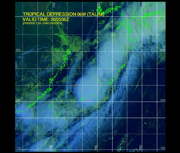
According to Joint Typhoon Warning Center (JTWC), Tropical Depression Talim is located 100 nm east of Taipei, Taiwan and it is moving east-northeastward at speed of 15 knots. Maximum sustained winds are 25 knots with gust up to 35 knots. Talim has weakened significantly due to negative terrain interaction with Taiwan and increased vertical wind shear associated with the Mei-Yu front.

Tropical storm Talim has produced torrential rainfall over southern Taiwan as it pumped warm moist air from the South China Sea over mountainous terrain. The TRMM satellite flew over tropical storm Talim in the Taiwan Strait on 20 June 2012 at 0140 UTC. TRMM Precipitation Radar (PR) data from this orbit shows that tropical storm Talim was dropping rainfall at a rate of almost 50mm/hr over Taiwan. TRMM data captured with that orbit shows that the most intense rainfall of over 50mm/hr (~2 inches) was located over the Strait Of Taiwan.
Flash flooding and landslides are probable in southern Taiwan due to heavy rainfall contributed by tropical storm Talim. That area of Taiwan has received almost 600 mm (~23.6 inches) of rainfall over the past week. Maps of potential landslide areas resulting from heavy rainfall are routinely produced and shown on the TRMM website.
Satellite Animations
- Storm-Centered Infrared (MTSAT; NOAA/SSD)
- Storm-Centered Infrared (Aviation Color Enhancement) (MTSAT; NOAA/SSD)
- Storm-Centered Water Vapor (MTSAT; NOAA/SSD)
- Storm-Centered Visible (MTSAT; NOAA/SSD)
- Storm-Centered Visible (Colorized) (MTSAT; NOAA/SSD)
- Tropical West Pacific Infrared (MTSAT2; NOAA)
- Tropical West Pacific Enhanced Infrared (MTSAT2; NOAA)
- Tropical West Pacific Water Vapor (MTSAT2; NOAA)
- Tropical West Pacific Visible (MTSAT2; NOAA)
Sources: JTWC, Japan Times, MODIS, TRMM
Studying the charts and graphs of these typhoons ads to the other disturbances taking place on and around those islands.
My nerves would be frayed beyond repair as the people of Japan are facing cesium and other radiation exposure, liquifaction, crop failure, contamination of food sources, uptick in earthquakes, volcanic eruptions, tsunamis, loss of life and now this.
Economic downturn is the least of their worries for the moment.
[…] Japan awaits typhoon Talim […]