Increasing seismic activities in Aegean Sea, Greece (with tectonic summary)
A moderate earthquake has struck off the northern coast of Greece near Heraklion, Crete for the second time in two days. The first earthquake had a magnitude 5.3 on Thursday, January 26, 2012 at depth of 14km, and the second earthquake had about the same magnitude – 5.4 at depth of 5km. Last January magnitude 6.2 hit Crete. Dodecanese archipelago also experienced strong shaking last few days with strongest earthquake measuring 4.8 yesterday.

From the start of the year we can see the increased seismic activities mainly around Aegean Sea region. Real Time Seismicity in Greece for the last 24 hours (Automatic Alerts)


Tectonic summary
The Mediterranean Sea has an average depth of 1,500 m (4,900 ft) and the deepest recorded point is 5,267 m (17,280 ft) in the Calypso Deep in the Ionian Sea. The geologic history of the Mediterranean is complex. It was involved in the tectonic break-up and then collision of the African and Eurasian plates. This process was driven by the differential spreading along the Atlantic ridge with Africa-Arabia moving north, which led to the closure of the Tethys Ocean and eventually to the Alpine orogenesis (The collision pushed up a vast system of mountains, extending from the Pyrenees in Spain to the Zagros Mountains in Iran). However, the Mediterranean also hosts wide extensional basins and migrating tectonic arcs, in response to its land-locked configuration.

The earth’s lithosphere beneath the eastern Mediterranean constitutes a broad boundary region between three major tectonic plates, the Eurasia, Africa, and Arabia plates. The motions of the major plates drive smaller plates, and it is the shapes and motions of these smaller plates that determine the locations and focal mechanisms of most earthquakes in the region. Most shallow earthquakes in central and northern Greece (depths less than 50 km) result from interaction between the Eurasia plate and the small Aegean Sea plate, which is moving southwest with respect to the Eurasia plate with a velocity of about 30 mm/year. The boundary between the Aegean plate and the Eurasia plate in central and northern Greece is diffuse.
Active subduction processes and ongoing migration of the continental and oceanic crustal plates led to the formation of a complicated geodynamic structure. Westward movement of the Minor Asia crustal block along the North Anatolian Fault, the one that moved during the catastrophic 1999 Istanbul earthquake, adds more complexity to the geodynamic organization of the area. Subduction of the Eastern Mediterranean lithosphere (the earth’s crust and upper mantle) beneath the Hellenic Orogenic Arc, and the following melting of the sinking sediments and rocks resulted in the formation of spectacular volcanoes and related volcanic structures in the Southern Aegean Sea. The volcanoes are aligned along a 500km long by 40km wide concave arc, known as the Hellenic Volcanic Arc. Some of the most famous South Aegean islands, like Santorini, Nisyros, Milos, Egina and Poros, together with other minor volcanic outcrops, represent the main volcanic centers of the Hellenic Volcanic Arc.
")

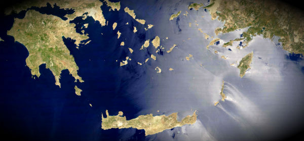
The Aegean Sea is an elongated embayment of the Mediterranean Sea located between the southern Balkan and Anatolian peninsulas, between the mainlands of Greece and Turkey. The sea’s maximum depth is 3,543 metres (11,624 ft), east of Crete. The Aegean Sea Plate (also called the Hellenic Plate) is a small tectonic plate located in the eastern Mediterranean Sea under southern Greece and far western Turkey. Its southern edge is a subduction zone south of Crete, where the African Plate is being swept under the Aegean Sea Plate. To the north is the Eurasian Plate which is a divergent boundary responsible for the formation of the Gulf of Corinth.


The Africa plate subducts beneath the Aegean Sea plate along the Hellenic arc, from the western Peloponnesus through Crete and Rhodes to western Turkey, at a rate of almost 40 mm/year. Shallow-focus earthquakes (focal depths less than 50 km) occur on faults in the boundary-region of the two plates. From Crete to the west and northwest, most shallow earthquakes near the Hellenic-arc plate boundary are produced as the result of reverse or strike-slip motion, although some normal-faulting earthquakes do occur. To the east of Crete, the Hellenic-arc plate boundary is characterized by normal-fault and strike-slip earthquakes. Shallow-focus earthquakes also occur in the volcanic arc that is associated with the subduction of the Africa plate beneath the Aegean Sea plate, in the Dodecanese and Cyclades Islands, over 100 km north of Crete. The region near the volcanic arc is characterized by normal faulting. A belt of shallow-focus seismicity along the western coast of Greece to the north of Lefkada, and extending north along the Adriatic coast of the Balkan Peninsula, is characterized by reverse fault earthquakes occurring in response to northeast-southwest crustal convergence.

Tectonic summary of Greece (USGS)
The eastern Mediterranean basin where the Anatolian plate extends, is one of the world’s most intense seismic zones where large destructive earthquakes occur with frequency. The geological instability and the resulting earthquakes are caused by the active grinding of the Anatolian plate wedged against the continental plates of Africa, Eurasia and Arabia. As these larger tectonic plates grind against the Anatolian plate, Asia Minor and Greece move, smashing closer together in some places and drawing apart in other regions.
Of a total of 613 known historic earthquakes, at least 41 major events generated documented tsunamis that struck coastal areas of the Greek mainland and the Aegean islands. Sixteen of these earthquakes resulted in really damaging or disastrous tsunamis. Between 1801 and 1958, 482 earthquakes with intensity equal or greater than VI, and 170 with intensity greater than VIII occurred. Twenty of these earthquakes resulted in tsunamis and six of these tsunamis were particularly damaging or disastrous in the Aegean and the Eastern Mediterranean Sea.
There is substantial historical evidence that large earthquakes near the island of Crete were responsible for the destruction of the Minoan palaces of the island, including Knossos. The first major destruction of the Palace of Knossos by earthquakes occurred around 1720 BC. After the palace was rebuilt and restored to its original splendor, it was again destroyed by the earthquakes of the fourteenth century BC. Tsunamis were responsible for subsequent destruction. The best documented and most recent earthquake in the Aegean Sea is the one that occurred on 9 July 1956 near the southwest coast of the island of Amorgos, killing 53 people, injuring 100, and destroying hundreds of houses. The waves were particularly high on the south coast of Amorgos and on the north coast of the island of Astypalaea. At these two places the reported heights of the tsunami were 25 and 20 m, respectively. (dr.GeorgePC)

The 1238 Tsunami
The 1238, like the 365 quake, was center south of Crete, where the African plate dives deep underneath the lighter Aegean plate. The shaking caused portions of the Cretan mainland, as well as the slops of several offshore islands to slump into the sea, in effect amplifying existing tsunamis. The end result was an enormous tsunami, the likes of which had not been seen in the Eastern Mediterranean Basin for a thousand years, and has not been seen since in this region. The Aegean itself was protected by the bulk of the island of Crete itself, and wave runups were comparatively small—at the extreme end, a wave of roughly 1.5 meters came ashore at Smyrna, causing moderate damage. To the south, however, the full energy of this massive shift had no intervening barriers to block its fury. Waves on the southern side of Crete were absolutely enormous—the village of Sephardion, we are told, was among those wiped out. In years past, it was simply assumed Sephardion was just another coastal community. However, thanks to archeological work by Lady Edessa, among others, we now know that the remains of Sephardion lie on a 17 meter high bluff, which implies truly enormous waves! Further to the south, waves did not reach such biblical proportions, but nonetheless waves at least 8 meters high struck most of Egypt and the Levant, in some cases depositing ships two or three kilometers inland, as well as devastating the Roman port cities of Alexandria, Damietta, Cyrene, Tripoli, Gaza, Acre, and Beirut. The toll that this disaster placed on the Roman world cannot be underestimated. In economic and human terms, the disaster likely took well over 200,000 lives… we are told some 30,000 in Alexandria alone. Ports from Acre and Gaza to Damietta and Alexandria itself were devastated. In particular, the damage to shipping and ports along the Egyptian coast caused a temporary, yet major disruption in Imperial grain shipping through 1239, which would have major political consequences of its own in Konstantinopolis. Yet the social ramifications of this event go beyond simply a shortage of grain, or the devastation of cities. (dr. Ismail Skleros)
Santorini and Columbo
Santorini caldera and the submerged Columbo volcano will be the next two survey areas of this project. Santorini, the most spectacular island in the Aegean Sea owes its exceptional landscape to the Minoan eruption in the 17th century BC and the formation of the famous caldera in the middle of the island. The caldera walls rise to over 300m above sea level while maximum depth of the caldera seafloor is about 360m. The Minoan eruption is considered the second largest eruption in historical times, after the Tambora volcano eruption in Indonesia in 1815.
Since the devastating Minoan eruption in the 17th century BC, many significantly weaker activity phases have occurred, and the landscape has continued to change even during very recent years. The Nea Kameni island in the centre of the caldera forms the summit of the actively growing new volcanic center. The ancient geographer Strabo was the first to record volcanic eruptions inside the Santorini caldera. He described the birth of a newly formed small island in 197 BC in the middle of caldera. Several eruptive phases followed the birth of Kameni islands in the years 46-47, 726, 1570-1573, 1707-1711, 1866-1870, 1925-1928, 1938-1941 and 1950 AD as the most recent eruption. Hydrothermal venting and formation of carbonate mounds and bacterial communities associated with the active hydrothermal sites on the seafloor have been reported previously from several places off the coasts of Nea Kameni as well on the caldera’s seafloor.

Columbo submarine volcano appeared first in 1650 AD some 8 km to the northeast of Cape Columbo, Santorini island. The strong sublinian eruption of Columbo lasted for 2-3 months, between September and December 1650. It produced ash and pumice fall and triggered a very strong tsunami, which devastated the coasts of the adjacent South Aegean islands. Toxic gases, emitted during the eruptive phase, was one of the reasons for the over 50 fatalities. A small island rose above the sea level at the place where the present day Columbo bank lies and disappeared shortly after. Nowadays the 18m Columbo bank represents the shallowest point of the submarine volcanic cone, on the rim which surrounds the 500m deep crater. The diameter of the crater rim is about 1.5km while the crater’s bottom is less than 500m in diameter.
Columbo submarine volcano is the biggest of several volcanic cones aligned in a northeast-southwest direction in the Anyhdros basin, to the northeast of Santorini. The Anyhdros basin is a 400-500m deep basin controlled by northeast-southwest trending faults. Steep slopes, developed along the marginal faults, bound the subsiding basin’s floor. Vertical and strike slip movements along steeply inclined fault surfaces result from the subsiding basin, and the deformation of the sedimentary deposits in it. The linear layout of the volcanic cones parallel to the main marginal faults of Anyhdros basin indicate that tectonic features may have played a main role in the spatial distribution of the submarine volcanoes. Active venting sites have been recently discovered and visually observed in the deep bottom of Columbo crater.
Thank you for sharing the this informatory article with us.
Fracking is not used in Greece. It is used only in a handful of countries in the world, for extracting oil from porous materials. Greece and surrounding areas have some unexploited good quality oil deposits. Long before fracking is used, these deposits will be exploited in the traditional way.
Earthquakes in Greece are very common and people don’t really care about another 5.5 or 6.0 earthquake. They do, however, react very vividly when the earthquake happens, so casualties are usually surprisingly low. An example is the 1953 Ionian Islands earthquake, that with a magnitude of 7.2 (Ms 7.4) caused less than 500 casualties, despite destroying at least 27000 houses. Foreshocks are fortunately very common in Greece, so people usually have the time to prepare. There is a good earthquake culture in the country, though nothing close to that of Japan.
The recent earthquakes mentioned in this beautiful article are not worrying at all. The waters north of Crete produce such earthquakes quite often, and in fact even some pretty strong ones, like the 1956 one that generated the big tsunami (M 7.5), but the ones near Crete are not as strong. The ones near Santorini, though, are considered more dangerous. After these earthquakes, the island is closely monitored and no threatening activities are detected in all these months.
Excellent, interesting, and beautiful website. Appreciate the info. Thanks for doing what you do.
Great piece.
I also have an eye on Santorini, Etna, El Hierro, Iceland et al.
For me, the biggest threat comes from the Azores islands where THREE plates meet. We haven’t had any movement there at all in relation to all the recent movement around the rest of the world…..Heads up Lisbon!!
Cheers,
Fred.
Are they scouting for oil round that area? using fracking?
fantastic post been keeping an eye on this area since last september and i think things might start getting intresting x
Why hasn’t there been more in the local media about this
And that’s a good question.But anyway, media can sometimes report about earthquakes coloured with fearmongering and sensationalism instead of giving people the real facts and figures in order of better understanding the area where people live and hazards that are possible so in that way people could stay prepared. Greece is seismically very active region in general and this area around Aegean sea is very important to understand plate tectonics in region and future development