Multiple vortex forming over Northern America
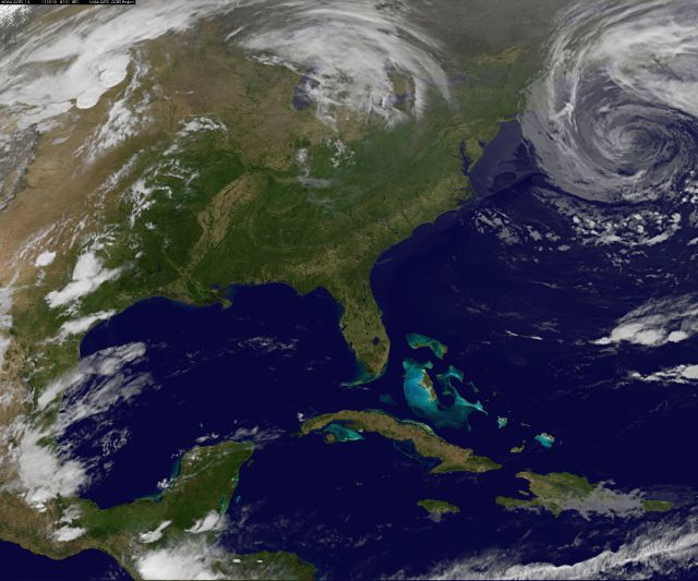
There is an upper level low pressure system vortex storm forming of East Coast of US. It’s an occluded front with a low pressure of 29.29hg or 992mb. The winds are rotating the system counterclockwise. In previous post we gave some possible explanation of the situation and we gave some notes about polar cyclones, arctic storms, nor’eastern storms and explanation of Coriolis effect.
The upper level low pressure systems are important to forecasting and can dramatically alter one’s forecast. Upper level lows can occur in association with a mid-latitude cyclone or may begin without the aid of a mid-latitude cyclone. Upper level lows without the aid of a surface low can develop when air flows over a mountain range, in association with an upper level short wave, or in association with a jet streak.

Upper level low pressure system
An upper level low is a region of positive vorticity. This positive vorticity can be caused by counterclockwise curvature around the upper level trough and counterclockwise shear associated with the speed shear of a jet streak. The circulation around an upper level low can build to the surface over time. In these cases, two areas of low pressure will be noticed on the surface chart. These are sometimes referred to as double-barrel low-pressure systems. Upper level lows can also decrease in intensity through time.

A huge forecasting problem is determining whether an upper level low will strengthen or weaken with time. When nowcasting, they are best viewed on satellite imagery. Image by image they should be monitored for intensity. When the clouds brighten (become whiter) in association with the upper level low, that is an indication the upper level low is strengthening.
If an upper level low does show on the analysis or forecast models it is best seen at the 500 millibar level or 700 millibar level. Upper level lows have been responsible for bringing unexpected heavy snows in the winter. The spin-up of vorticity in an upper level low causes the air to rise and cool. Since the upper level low is tilted over the cold air, cold surface temperatures and upper level lifting combine to produce wintry precipitation well behind (to the west or northwest) or the surface cold front. When a mid-latitude cyclone begins to mature, watch for the development of the upper level low.
SEAS GIVEN AS SIGNIFICANT WAVE HEIGHT...WHICH IS THE AVERAGE

 HEIGHT OF THE HIGHEST 1/3 OF THE WAVES. INDIVIDUAL WAVES MAY BE

 MORE THAN TWICE THE SIGNIFICANT WAVE HEIGHT.

NWS MARINE FORECAST

This is a low pressure strengthened and further strengthening is expected. Breaking waves in near the north US coast could reach 20 feet tall. This system is increasing in force affecting the surf as far away as the Dominican Republic this week. There is no risk of rain, but a heavy swell, which probably will be a historic show. The system probably meets up with SW system in the Midwest. More worries for flooded Mississippi valley. All that cold air being fed from Canada and all the warm air being sucked from the South. And it is headed in the complete opposite direction. It is heading South. It should be going East North East.
Eastern U. S. – Infrared Channel 2 Loop
North Atlantic – JSL Color Infrared Loop
GOES Composite – Central U.S. Imagery – Water Vapor Loop
East Conus Water Vapor Loop
Atlantic Water Vapor Loop

Three, possible four total systems forming on North American Continent. One Vortex Over Alaska, One Vortex in Mid West states and the Vortex on the East Coast.
Don’t forget about 2 giant swirls near Guayanna coast and tropical storm Aere that is heading toward Japan.

AccuWeather forecasters warn about violent storms across US Wendsday to Thursday.
Some of the strongest thunderstorms from this afternoon and evening will linger across Tornado Alley late tonight into Thursday morning. As is the case today, a greater number of potentially damaging thunderstorms will then ignite on Thursday afternoon. Thursday’s severe weather threat will lie slightly east of today’s zone, stretching from Iowa to South Texas. Spottier, but still violent thunderstorms will reach the flooded lower Mississippi Valley on Thursday. More numerous thunderstorms, however, will deliver unwanted rain on Thursday night into Friday.
Strong thunderstorms could rattle a zone from Cincinnati, Ohio, to Myrtle Beach, S.C. into tonight. The threat for severe weather on Wednesday will extend from the western Great Lakes southwestward to southwestern Texas. A wedge of dry air will delight much of the Northeast this week. However, wet weather will return in time for the weekend. Another system nearing the southern High Plains will trigger strong thunderstorms from western Oklahoma into central Texas later today into tonight. Areas from Texas to Illinois and southern Wisconsin will be the primary focus of the storms with this severe weather outbreak that will include large hail, damaging straight-line wind gusts and a couple of handfuls of tornadoes.
STAY TUNED FOR MORE INFO!!!

During the past week or so, weather systems moving along through the Midwest have not had access to Gulf of Mexico moisture, which is a key ingredient for the nastiest of thunderstorms known as supercells. These supercells are the main producers of tornadoes. During the severe weather outbreak this week, the Gulf of Mexico will be open and will add in the necessary ingredient for the violent storms. This outbreak has the potential to produce a couple dozen or so tornadoes, a few of which could be strong, and should be taken seriously.


Looking further into subject – connecting some dots: East Coast Vortex, Maine Earthquake Swarm, Strange Noises, HAARP and 9/11 History
redjack992 commented on The Watchers:
First time I see anything like this forming so north, really strange…