Heavy Rain in Namibia and South Africa
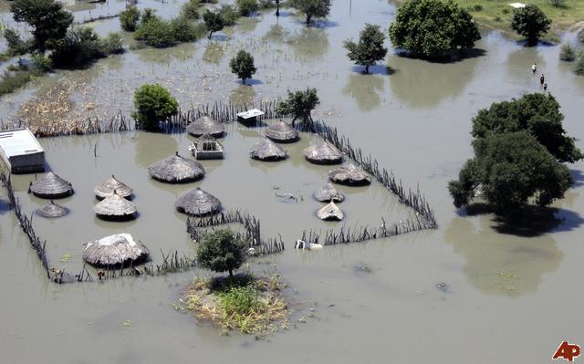
In early May 2011, more rain fell in one day in parts of Namibia and South Africa than typically falls in an entire year. For several months, unusually heavy and persistent rains have soaked western Africa and filled rivers and basins that have been quiescent for years. The latest storm moistened arid desert regions.
The map below depicts rainfall for Namibia and South Africa on May 5, 2011. The estimates were made from the Multi-satellite Precipitation Analysis, based on data from the Tropical Rainfall Measuring Mission (TRMM). Shown in shades of green and blue, rainfall estimates range from 20 millimeters (0.8 inches) to greater than 70 millimeters (2.8 inches). In much of the Namib desert near the coast, less than 20 millimeters of rain fall in a year.

The photo depicts what is likely a “shelf cloud” associated with a high precipitation supercell thunderstorm. The clouds are pulled nearly to ground level by extremely strong downdrafts. As large amounts of rain fall, and larger and heavier rain droplets pull the air down with them. As the cold, wet air reaches the desert floor, it makes a wedge of condensed water. The curl at the bottom occurs because the down-drafting winds hit the Earth’s surface and have to spread out.
The bullseye precipitation pattern depicted in the top image occurs because these storms are short-lived and dump large amounts of rain very quickly in one area.
Since February, rainfall has been above average in many parts of sub-Saharan African—in Angola, northern Namibia, southern Tanzania, Cameroon, Congo, and Madagascar—according to the Climate Prediction Center of the U.S. National Weather Service. The Kuiseb, Boteti, and other rivers have approached record highs. (EO)
Climate Prediction Center – African Desk
Barry Monette commented on The Watchers:
Here is a possible scenario:
CO2 induced global warming from GHG effect causes surface warming resulting in significant water vapor (humidity) through evaporation. The water vapor intensifies the green house effect five fold. But the increased clouds from all this soon form a reflective barrier in the sky and reflect sunlight away before it hits the ground. This cools the water in the clouds. no longer heated up because the sunshine is missing, and it rains hard plus increases various wind impacts.
This is like a new type of global monsoon condition that changes weather patterns. The cycle might take a few years before it starts over again. It will repeat over and over. Places where there is not much water on the ground to start will be less affected because there is little to evaporate and start this process.
Noushka commented on The Watchers:
Unbelievable…
I feel really sorry for these guys not used to so much rain…
But with what’s going on lately (Haarp…), who could seriously be surprised!