Earthquake swarm in American Samoa continues, source beneath Manu’a Islands
The earthquake swarm in American Samoa continues without significant changes. Residents reported that earthquakes began about 3 weeks ago, with the first felt earthquake reported on July 26, 2022, USGS Hawaiian Volcano Observatory (HVO) reports.
Approximately 20 earthquakes per hour are being recorded by the two microseismometers installed in the Manuʻa islands, but most of them are too small to be felt.
Estimated magnitudes of the largest earthquakes, including the felt events, are between M2 and 3.
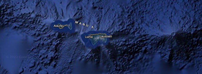
Seismic data indicate that the source for these earthquakes is beneath the Manuʻa Islands, likely closer to Taʻū island rather than Ofu-Olosega, and are not related to Vailuluʻu seamount.
Reports from both Taʻū and Ofu-Olosega islands suggest that the earthquakes vary in intensity, but are generally short, sharp jolts.
The earthquakes are more likely to be felt by people indoors at rest and along the coast, where buildings sit on sediment that amplifies shaking. These factors are probably responsible for the variability in reporting.
Current low-level earthquake activity may continue and vary in intensity for days to months or longer without an eruption, HVO said. It is also possible that the swarm is an early precursor to an eventual eruption.
“At this time, we cannot determine which of these possibilities is more likely. A large explosive eruption similar to the Tonga eruption earlier this year is extremely unlikely. ”1
Geological summary
The 10 km (6.2 miles) wide Ta’u Island, located at the E end of the Samoan islands, is ringed by sea cliffs. It is the emergent portion of the large Lata shield volcano.
A major flank collapse event around 22 ka resulted in the steep scarps on the southern side of the island. Two smaller shields were constructed along rift zones at the NW and NE tips of the island.
The NW corner of the island has a tuff-cone complex that ejected large dunite xenoliths and coral blocks. Numerous Holocene post-caldera cones occur at the summit and on the flanks.2
References:
1 HAWAIIAN VOLCANO OBSERVATORY INFORMATION STATEMENT – U.S. Geological Survey -Thursday, August 18, 2022, 08:35 UTC
2 Ta’u – Geological summary – GVP
Featured image credit: TW/SAM, Google
Commenting rules and guidelines
We value the thoughts and opinions of our readers and welcome healthy discussions on our website. In order to maintain a respectful and positive community, we ask that all commenters follow these rules:
We reserve the right to remove any comments that violate these rules. By commenting on our website, you agree to abide by these guidelines. Thank you for helping to create a positive and welcoming environment for all.