Severe Tropical Cyclone “Niran” heading toward New Caledonia
Severe Tropical Cyclone "Niran" (Category 5 on the Australian scale) is tracking ESE at 46 km/h (28 mph) and is forecast to pass very near New Caledonia on Saturday, March 6, 2021.
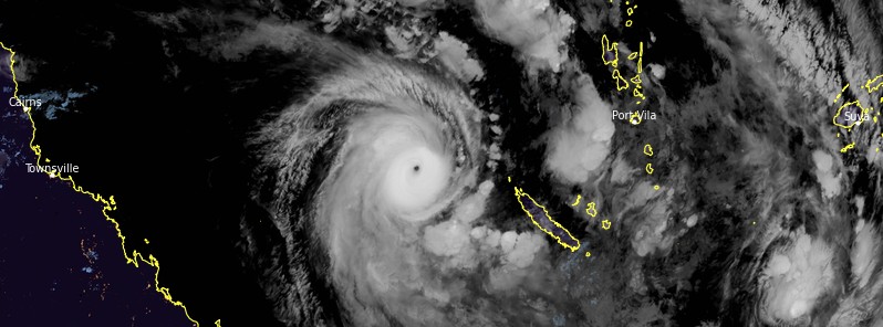
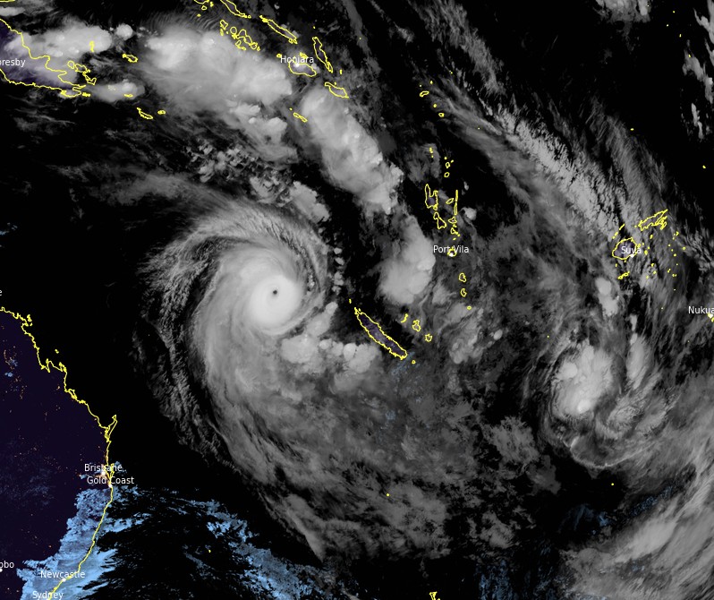
At 11:00 UTC on March 5, Niran had a central pressure of 931 hPa and was located over the Coral Sea, about 1 070 km (665 miles) ENE of Mackay, Australia, and 860 km (535 miles) WNW of Noumea, New Caledonia, according to the Australian Bureau of Meteorology (BOM).
Its maximum sustained winds were 205 km/h (125 mph) and gusts to 285 km/h (175 mph).
Northerly shear is increasing which will result in some weakening of the system, but model guidance shows a vertically stacked system remaining through the next 12 – 18 hours and hence it is possible some further intensification occurs overnight supported by sea surface temperatures above 28 °C (82 °F) and the strong outflow channels poleward.
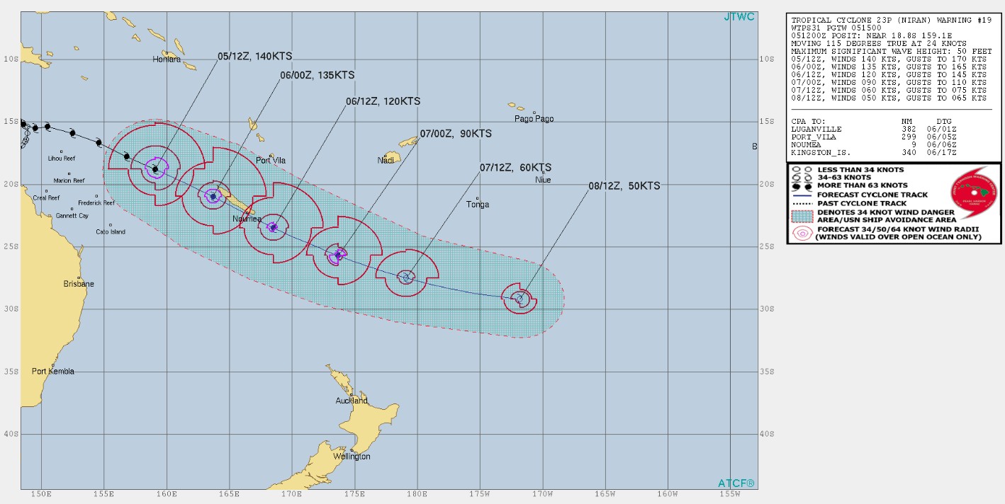
There is high confidence that the system will maintain an east-southeast track passing near New Caledonia on Saturday, March 6, BOM said. This motion will continue as a result of an upper trough that is currently moving across eastern Australia. The circulation should then be weakening under northwesterly shear and cooler sea surface temperatures.
Heavy rain, strong wind, and high waves could affect especially western New Caledonia from the late evening (LT) March 5.
A Level 2 Cyclone Alert has been issued for the whole of New Caledonia.
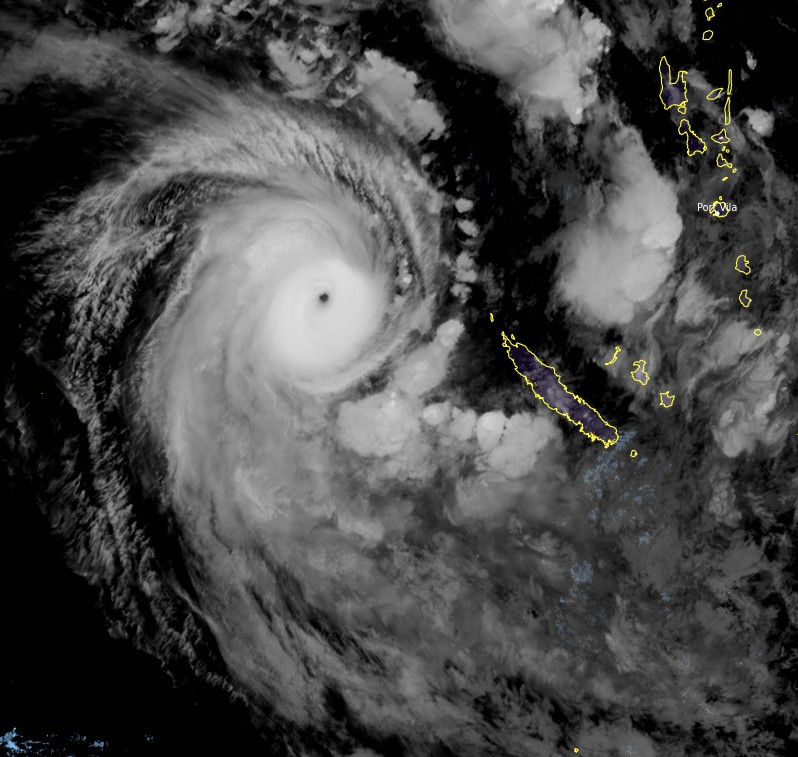
Severe Tropical Cyclone "Niran" at 14:20 UTC on March 5, 2021. Credit: JMA/Himawari-8, RAMMB/CIRA, TW
Niran is moving out of the Australian area of responsibility for tropical cyclone forecasting (expected to exit before 18:00 UTC today) and no further Tropical Cyclone Information Bulletins will be issued by BOM. The next warning will be issued by Nadi Tropical Cyclone Warning Centre.
Niran formed on March 1 and began to slowly pull away from the coast. It reached Category 3 status on the Australian scale late on March 3 and then Category 4 on March 4.
Despite never making landfall, Niran brought strong winds and heavy rains to parts of Queensland, from Cape Flattery to the Lucinda region.
Heavy agricultural damage has been reported, with more than $180 million in banana crop damage.
Since Queensland accounts for 94% of the entire Australian banana production, banana prices could jump to as much as $14 per kg.
A similar case took place in 2006 and again in 2011, when damages caused by cyclones Larry and Yasi, caused banana prices to jump from $2 to $14 per kg.
Featured image: Severe Tropical Cyclone "Niran" at 14:20 UTC on March 5, 2021. Credit: JMA/Himawari-8, RAMMB/CIRA, TW
Commenting rules and guidelines
We value the thoughts and opinions of our readers and welcome healthy discussions on our website. In order to maintain a respectful and positive community, we ask that all commenters follow these rules:
We reserve the right to remove any comments that violate these rules. By commenting on our website, you agree to abide by these guidelines. Thank you for helping to create a positive and welcoming environment for all.