Strong winter storm brings snow, floods and mudslides to California
A potent winter storm brought heavy rain, floods, mudslides and mountain snow to southern California on December 6 and 7, 2018. The storm will track across the Southern Plains to the Southeast Coast from Friday through Sunday, December 9. Ice and snow will overspread eastern New Mexico, the Texas Panhandle, and western Oklahoma by late Friday into Saturday, while heavy rain develops across southeast Texas, western Louisiana and southern Arkansas.
This is the second storm in a week to hit the drought-stricken region. It dropped record-breaking rain, caused floods, mudslides and major traffic disruptions.
According to NBC4 meteorologist Anthony Yanez, rain amounts in and around Los Angeles ranged from 12.7 mm (0.5 inches) to nearly 102 mm (4 inches) with snow at 12.7 cm (6 inches) and counting.
NWS Los Angeles said 12.7 mm (0.5 inches) of rain fell in 1 hour in Agoura. Downtown Los Angeles recorded its highest amount of rain for December 6 with 1.9 inches (48.2 mm) of rain, beating the previous high of 1.01 inches (25.6 mm) set in 1997.
Normal monthly rainfall for December in Los Angeles is about 59.1 mm (2.33 inches).
Rainfall summary for our recent storm with many areas receiving 2 inches or more. The highest amounts were in the San Gabriel Mtns with 4-5 inches along with up to a foot of snow above 6000 ft. Several inches of snow closed the #Grapevine I5 highway as well. #CAwx #LArain pic.twitter.com/2xufQ7o66E
— NWS Los Angeles (@NWSLosAngeles) December 7, 2018
One person died after a vehicle overturned in the Sun Valley of Los Angeles, shutting down numerous lanes.
NB I-5 at Hollywood Way in #SunValley– 3 left lanes blocked- overturned vehicle with fatality- unknown duration https://t.co/zqxNFKXp7h #Storm #Rain #TrafficAlert pic.twitter.com/zkhHchIvhW
— Caltrans District 7 (@CaltransDist7) December 6, 2018
A mudslide closed a 10-mile stretch (16 km) of State Route 1, in both directions from western Malibu to the Ventura County Line. The California Department of Transportation said the closure occurred in the vicinity of last month's Woolsey fire and urged commuters to find other routes.
The department added that many areas between Redding and Riverside County are at risk of mudslides and flooding after wildfires stripped the land bare.
Part of State Route 23 was also closed to provide safe space to work on a winding road with narrow shoulders and steep cliffs.
A rockslide in the Angeles National Forest closed State Route 2, northeast of Los Angeles, in both directions between the Vincent Gulch Divide and State Route 39, Caltrans said.
Numerous other roads were shut down due to mudslides and loosened rock slides, AccuWeather's Mark Puleo writes.
Mudslides in the burn scar areas have trapped cars and covered roads in debris, while in Orange County, the Sheriff's Department issued a voluntary evacuation warning to residents.
#Grapevine #Snow gridlock pic.twitter.com/DJM1zzoWbr
— christina heller (@CHellerTVNews) December 6, 2018
SIGALERT: Two right southbound lanes on State Route 57 from Covina Blvd to Via Verde Ave near San Dimas are CLOSED until about 5:30 p.m. due to big rig traffic collision. pic.twitter.com/gFHou7xM0E
— Caltrans District 7 (@CaltransDist7) December 7, 2018
SB I-5 at the truck lanes at SR-14- overturned tractor trailer- unloading cargo -tow on scene #trucklanes #rain #storm pic.twitter.com/F0iD1UWIfG
— Caltrans District 7 (@CaltransDist7) December 6, 2018
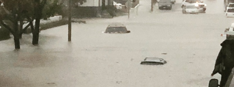
That’s 17th Street and Pomona Avenue. Please find alternate routes and stay away from that area until water level subsides. pic.twitter.com/od1vvjRqaJ
— Costa Mesa Police (@CostaMesaPD) December 6, 2018
Costa Mesa is flooding! #rainyday #raininsocal pic.twitter.com/fkBtU1Q7Ae
— Lisa Beachy (@lsbeachy) December 6, 2018
Per LASD Reserve Officer Tommy Fakehany:
Heavy mud flow at #PCH and Leo Carrillo. All traffic is being turned around and the area is not passable. #malibu #woolseyfire #traffic PC: Tommy Thomas Tommy Fakehany pic.twitter.com/YCj1l6fKPI— Cece Woods (@Cece90265) December 6, 2018
Car navigates around large rock on #Topanga Canyon Road. @NWSLosAngeles warns loosened rocks and boulders could tumble down from #WoolseyFire burn scar @CBSLA @DanielleGersh @suzmarques @CBSLAPeter pic.twitter.com/gNEaBL3DVo
— Kara Finnstrom (@KaraFinnstrom) December 6, 2018
SR-23 – photos of mud in the roadway this morning at various points within the closure between upper Mulholland Dr & PCH #storm #WoolseyFire #rain pic.twitter.com/FCGlMmS2bd
— Caltrans District 7 (@CaltransDist7) December 6, 2018
#Rain #Rockslides. #LasVirgenesCanyon Boulder falls off cliff and slams into flatbed truck disabling it. #LACountyFire called in to dislodge other rocks to make roadway safe @KNX1070 pic.twitter.com/pEofeBeVJs
— Pete Demetriou (@knxpete) December 6, 2018
SB I-5 at the truck lanes at SR-14- overturned tractor trailer- tow on scene #rain pic.twitter.com/1i1IGBg86U
— Caltrans District 7 (@CaltransDist7) December 6, 2018
Interstate 5 CLOSED between Parker Road in Castaic and Grapevine Road in Kern County due to snow and ice..@NWSLosAngeles @FOXLA pic.twitter.com/l34XsSq2Dx
— Rick Dickert (@RICKatFOX) December 6, 2018
It's a Winter Wonderland in mountain regions! Don't forget your chains! Drive safe out there. #caltrans8 pic.twitter.com/HusrkyZ784
— Caltrans District 8 (@Caltrans8) December 6, 2018
A roof of Homeroom Hourly Child Care center in the San Diego suburb of Carlsbad collapsed due to heavy rain. Authorities said children, employees and pets were inside but nobody was injured.
A Southwest plane skidded off a wet runway as it landed during heavy rain at Hollywood Burbank Airport north of Los Angeles, AP reports.
The Federal Aviation Administration says no injuries were reported. Their spokesman said the plane came to a stop in a graded area designed to slow aircraft that overshoot the runway.
"The storm system crossing the Desert Southwest early Friday morning will take a southerly track across the southern plains to the Deep South and then the southeast U.S. coast through the weekend," NWS forecaster Hamrick noted December 7.
Snow and freezing rain is forecast to overspread eastern New Mexico and the Texas/Oklahoma panhandles by late Friday, and continuing into early Saturday.
The greatest snowfall accumulations through early Saturday are expected across the southern High Plains from eastern New Mexico and across parts of the Texas Panhandle, with amounts on the order of 75 – 150 mm (3 to 6 inches) and locally higher.
In addition, ice accretion of about a tenth of an inch, perhaps higher, will be possible on the southern edge of the heavier snow band, roughly from Lubbock to Oklahoma City.
In the warm sector of the surface low, heavy rain is forecast across southeast Texas in response to a deep surge of moisture from the Gulf of Mexico, Hamrick said.
The Weather Prediction Center currently has a Moderate Risk of excessive rainfall for Friday and Friday night for much of southeast Texas, with several inches of rainfall expected.
The rainfall rates are expected to be high at times, increasing the threat of flooding. Flash flood watches are also in effect for this region.
A slight risk of excessive rainfall exists through Saturday night for the central Gulf Coast region as heavy bands of showers and thunderstorms develop in conjunction with the surface low and a deep moisture surge ahead of it.
As the surface low tracks eastward roughly along the Gulf Coast through late Sunday, a swath of accumulating snow and ice is expected to extend from eastern Oklahoma to the southern Appalachians.
Winter storm watches are now in effect from the Texas Panhandle to the Ozarks of northern Arkansas, and also for the southern Appalachians and adjacent Piedmont region.
Travel will likely be severely affected across much of these areas, and some power outages are also possible.
Elsewhere across the nation, some lake effect snow is likely across parts of Michigan and New York for Friday and Saturday as cold northwesterly flow crosses the warmer lake waters.
Showers and mountain snow returns to western Washington and Oregon on Saturday as a cold front approaches from the eastern Pacific. Colder than normal temperatures are expected to persist across much of the central and northern U.S. through Saturday with a large Canadian surface high in place.
Featured image: Flooding on 17th Street and Pomona Avenue. Credit: Costa Mesa Police
Commenting rules and guidelines
We value the thoughts and opinions of our readers and welcome healthy discussions on our website. In order to maintain a respectful and positive community, we ask that all commenters follow these rules.